Sant'Angelo d'Alife elevation
Sant'Angelo d'Alife (Campania, Provincia di Caserta), Italy elevation is 356 meters and Sant'Angelo d'Alife elevation in feet is 1168 ft above sea level [src 1]. Sant'Angelo d'Alife is a seat of a third-order administrative division (feature code) with elevation that is 34 meters (112 ft) bigger than average city elevation in Italy.
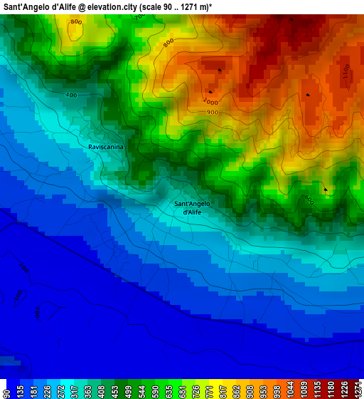
Below is the Elevation map of Sant'Angelo d'Alife, which displays elevation range with different colors. Scale of the first map is from 90 to 1271 m (295 to 4170 ft) with average elevation of 435.3 meters (=1428 ft) [note 1]
These maps also provides idea of topography and contour of this city, they are displayed at different zoom levels. More info about maps, scale and edge coordinates you can find below images.
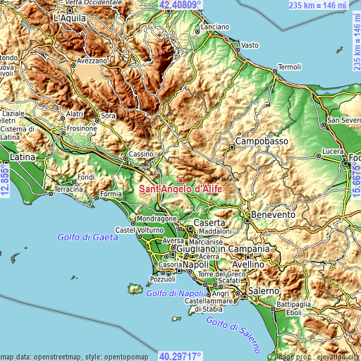
| \ | Map #1 | Topo.Map |
| Scale [m] | 90..1271 m | × |
| Scale [ft] | 295..4170 ft | × |
| Average | 435.3 m = 1428 ft | × |
| Width | 7.33 km = 4.6 mi | 234.7 km = 145.8 mi |
| Height | 7.33 km = 4.6 mi | 234.7 km = 145.8 mi |
| ↑Max Latitude | 41.394165° | 42.40809° |
| Latitude at center | 41.36119° | 41.36119° |
| ↓Min Latitude | 41.328198° | 40.29717° |
| ← Min Longitude | 14.217305° | 12.855° |
| Longitude center | 14.26125° | 14.26125° |
| →Max Longitude | 14.305195° | 15.6675° |
Nearby cities:
Cities around Sant'Angelo d'Alife sort by population:
• Piedimonte Matese elevation 158 m
9 km,  97°
97°
• Alife 105 m
7.2 km,  122°
122°
• Pietravairano 128 m
8.9 km,  243°
243°
• Dragoni 116 m
10.1 km,  159°
159°
• Castello del Matese 466 m
9.7 km,  86°
86°
• Baia 113 m
6.5 km,  188°
188°
• Valle Agricola 696 m
7.1 km,  356°
356°
• Prata Sannita Centro 324 m
9.3 km,  328°
328°
• San Gregorio Matese 779 m
9.6 km,  73°
73°
• Ailano 229 m
5.7 km,  304°
304°
• Raviscanina 356 m
1.8 km,  305°
305°
• Pratella 169 m
8.5 km, 305°
Multilingual:
 En español:
Sant'Angelo d'Alife elevación 356 m.
 En France:
Sant'Angelo d'Alife élévation 356 m.
 Auf Deutsch:
Sant'Angelo d'Alife höhe über dem Meeresspiegel ist 356 m.
 На русском:
Sant'Angelo d'Alife высота над уровнем моря 356 м
Sources and notes:
- [note 1] Map square and city borders are not equal. Map elevation data is calculated only from area inside that square.
- [src 1] Elevation data from geonames database provided with same terms of usage.
- [src 2] The elevation map of Sant'Angelo d'Alife is generated using elevation data from NASA's 3 arcsec (90m) resolution SRTM data.
- [src 3] Base (background) map © OpenStreetMap contributors tiles are generated by Geofabrik and OpenTopoMap.
Copyright & License:
This Sant'Angelo d'Alife Elevation Map is licensed under CC BY-SA. You may reuse any part from this page, if you give a proper credit by linking to this URL:
 More info on terms of use page.