Dragoni elevation
Dragoni (Campania, Provincia di Caserta), Italy elevation is 116 meters and Dragoni elevation in feet is 381 ft above sea level [src 1]. Dragoni is a populated place (feature code) with elevation that is 206 meters (676 ft) smaller than average city elevation in Italy.
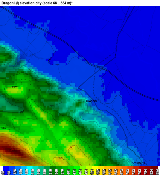
Below is the Elevation map of Dragoni, which displays elevation range with different colors. Scale of the first map is from 68 to 854 m (223 to 2802 ft) with average elevation of 205.9 meters (=676 ft) [note 1]
These maps also provides idea of topography and contour of this city, they are displayed at different zoom levels. More info about maps, scale and edge coordinates you can find below images.
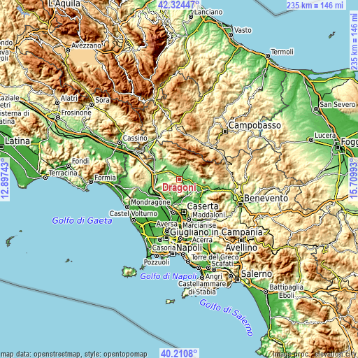
| \ | Map #1 | Topo.Map |
| Scale [m] | 68..854 m | × |
| Scale [ft] | 223..2802 ft | × |
| Average | 205.9 m = 676 ft | × |
| Width | 7.34 km = 4.6 mi | 235 km = 146 mi |
| Height | 7.34 km = 4.6 mi | 235 km = 146 mi |
| ↑Max Latitude | 41.309208° | 42.32447° |
| Latitude at center | 41.27619° | 41.27619° |
| ↓Min Latitude | 41.243155° | 40.2108° |
| ← Min Longitude | 14.259735° | 12.89743° |
| Longitude center | 14.30368° | 14.30368° |
| →Max Longitude | 14.347625° | 15.70993° |
Nearby cities:
Cities around Dragoni sort by population:
• Piedimonte Matese elevation 158 m
9.9 km,  32°
32°
• Pietramelara 141 m
9.8 km,  266°
266°
• Alife 105 m
6.1 km,  24°
24°
• Alvignano 133 m
4.5 km,  142°
142°
• San Giorgio 110 m
1 km,  129°
129°
• Castel di Sasso 202 m
9.6 km,  193°
193°
• Baia 113 m
5.4 km,  304°
304°
• San Potito Sannitico 239 m
10 km,  47°
47°
• Formicola 202 m
9.3 km,  218°
218°
• Sant'Angelo d'Alife 356 m
10.1 km,  339°
339°
• Liberi 466 m
5.6 km, 191°
• Roccaromana 149 m
6.8 km, 267°
Multilingual:
 En español:
Dragoni elevación 116 m.
 En France:
Dragoni élévation 116 m.


Sources and notes:
- [note 1] Map square and city borders are not equal. Map elevation data is calculated only from area inside that square.
- [src 1] Elevation data from geonames database provided with same terms of usage.
- [src 2] The elevation map of Dragoni is generated using elevation data from NASA's 3 arcsec (90m) resolution SRTM data.
- [src 3] Base (background) map © OpenStreetMap contributors tiles are generated by Geofabrik and OpenTopoMap.
Copyright & License:
This Dragoni Elevation Map is licensed under CC BY-SA. You may reuse any part from this page, if you give a proper credit by linking to this URL:
 More info on terms of use page.