Baia elevation
Baia (Campania, Provincia di Caserta), Italy elevation is 113 meters and Baia elevation in feet is 371 ft above sea level [src 1]. Baia is a seat of a third-order administrative division (feature code) with elevation that is 209 meters (686 ft) smaller than average city elevation in Italy.
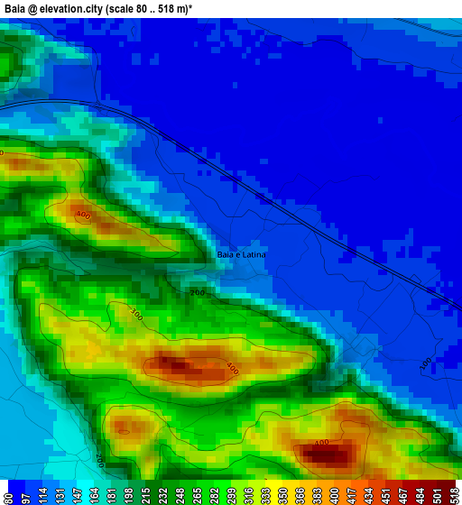
Below is the Elevation map of Baia, which displays elevation range with different colors. Scale of the first map is from 80 to 518 m (262 to 1699 ft) with average elevation of 182.3 meters (=598 ft) [note 1]
These maps also provides idea of topography and contour of this city, they are displayed at different zoom levels. More info about maps, scale and edge coordinates you can find below images.
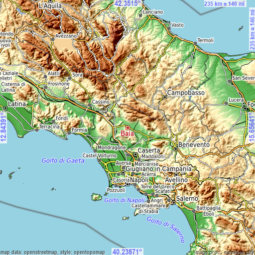
| \ | Map #1 | Topo.Map |
| Scale [m] | 80..518 m | × |
| Scale [ft] | 262..1699 ft | × |
| Average | 182.3 m = 598 ft | × |
| Width | 7.34 km = 4.6 mi | 234.9 km = 146 mi |
| Height | 7.34 km = 4.6 mi | 234.9 km = 146 mi |
| ↑Max Latitude | 41.336664° | 42.3515° |
| Latitude at center | 41.30366° | 41.30366° |
| ↓Min Latitude | 41.270639° | 40.23871° |
| ← Min Longitude | 14.206215° | 12.84391° |
| Longitude center | 14.25016° | 14.25016° |
| →Max Longitude | 14.294105° | 15.65641° |
Nearby cities:
Cities around Baia sort by population:
• Pietramelara elevation 141 m
6.4 km,  235°
235°
• Alife 105 m
7.4 km,  70°
70°
• Alvignano 133 m
9.8 km,  132°
132°
• Pietravairano 128 m
7.4 km,  288°
288°
• Dragoni 116 m
5.4 km,  124°
124°
• Riardo 136 m
9.5 km, 240°
• San Giorgio 110 m
6.4 km, 125°
• Sant'Angelo d'Alife 356 m
6.5 km,  8°
8°
• Ailano 229 m
10.3 km,  338°
338°
• Raviscanina 356 m
7.5 km,  355°
355°
• Liberi 466 m
9.2 km,  158°
158°
• Roccaromana 149 m
4.1 km,  215°
215°
Multilingual:
 En español:
Baia elevación 113 m.
 En France:
Baia élévation 113 m.


Sources and notes:
- [note 1] Map square and city borders are not equal. Map elevation data is calculated only from area inside that square.
- [src 1] Elevation data from geonames database provided with same terms of usage.
- [src 2] The elevation map of Baia is generated using elevation data from NASA's 3 arcsec (90m) resolution SRTM data.
- [src 3] Base (background) map © OpenStreetMap contributors tiles are generated by Geofabrik and OpenTopoMap.
Copyright & License:
This Baia Elevation Map is licensed under CC BY-SA. You may reuse any part from this page, if you give a proper credit by linking to this URL:
 More info on terms of use page.