Roccaromana elevation
Roccaromana (Campania, Provincia di Caserta), Italy elevation is 149 meters and Roccaromana elevation in feet is 489 ft above sea level [src 1]. Roccaromana is a seat of a third-order administrative division (feature code) with elevation that is 173 meters (568 ft) smaller than average city elevation in Italy.
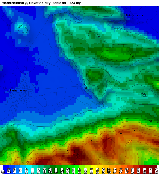
Below is the Elevation map of Roccaromana, which displays elevation range with different colors. Scale of the first map is from 99 to 934 m (325 to 3064 ft) with average elevation of 314.6 meters (=1032 ft) [note 1]
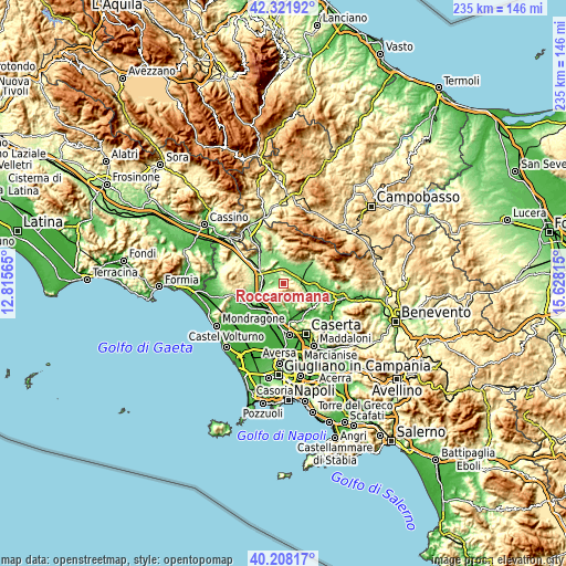
These maps also provides idea of topography and contour of this city, they are displayed at different zoom levels. More info about maps, scale and edge coordinates you can find below images.
| \ | Map #1 | Topo.Map |
| Scale [m] | 99..934 m | × |
| Scale [ft] | 325..3064 ft | × |
| Average | 314.6 m = 1032 ft | × |
| Width | 7.34 km = 4.6 mi | 235 km = 146 mi |
| Height | 7.34 km = 4.6 mi | 235 km = 146 mi |
| ↑Max Latitude | 41.30662° | 42.32192° |
| Latitude at center | 41.2736° | 41.2736° |
| ↓Min Latitude | 41.240564° | 40.20817° |
| ← Min Longitude | 14.177955° | 12.81565° |
| Longitude center | 14.2219° | 14.2219° |
| →Max Longitude | 14.265845° | 15.62815° |
Nearby cities:
Cities around Roccaromana sort by population:
• Pietramelara elevation 141 m
2.9 km,  264°
264°
• Pietravairano 128 m
7.4 km,  320°
320°
• Dragoni 116 m
6.8 km,  87°
87°
• Riardo 136 m
6.1 km, 257°
• San Giorgio 110 m
7.6 km, 92°
• Baia 113 m
4.1 km,  35°
35°
• Formicola 202 m
7.1 km,  171°
171°
• Giano Vetusto 203 m
8.2 km,  196°
196°
• Pozzillo 214 m
8.1 km, 195°
• Liberi 466 m
7.7 km,  132°
132°
• Pontelatone 136 m
9.1 km, 165°
• Rocchetta 440 m
6.7 km,  232°
232°
Multilingual:
 En español:
Roccaromana elevación 149 m.
 En France:
Roccaromana élévation 149 m.
 Auf Deutsch:
Roccaromana höhe über dem Meeresspiegel ist 149 m.

Sources and notes:
- [note 1] Map square and city borders are not equal. Map elevation data is calculated only from area inside that square.
- [src 1] Elevation data from geonames database provided with same terms of usage.
- [src 2] The elevation map of Roccaromana is generated using elevation data from NASA's 3 arcsec (90m) resolution SRTM data.
- [src 3] Base (background) map © OpenStreetMap contributors tiles are generated by Geofabrik and OpenTopoMap.
Copyright & License:
This Roccaromana Elevation Map is licensed under CC BY-SA. You may reuse any part from this page, if you give a proper credit by linking to this URL:
 More info on terms of use page.