Chiampo elevation
Chiampo (Veneto, Provincia di Vicenza), Italy elevation is 214 meters and Chiampo elevation in feet is 702 ft above sea level [src 1]. Chiampo is a seat of a third-order administrative division (feature code) with elevation that is 108 meters (354 ft) smaller than average city elevation in Italy.
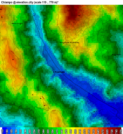
Below is the Elevation map of Chiampo, which displays elevation range with different colors. Scale of the first map is from 119 to 770 m (390 to 2526 ft) with average elevation of 368.3 meters (=1208 ft) [note 1]
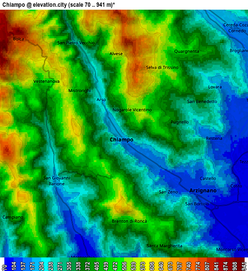
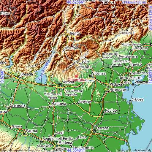
These maps also provides idea of topography and contour of this city, they are displayed at different zoom levels. More info about maps, scale and edge coordinates you can find below images.
| \ | Map #1 | Map #2 | Topo.Map |
| Scale [m] | 119..770 m | 70..941 m | × |
| Scale [ft] | 390..2526 ft | 230..3087 ft | × |
| Average | 368.3 m = 1208 ft | 366.5 m = 1202 ft | × |
| Width | 6.84 km = 4.3 mi | 13.69 km = 8.5 mi | 219 km = 136.1 mi |
| Height | 6.84 km = 4.3 mi | 13.69 km = 8.5 mi | 219 km = 136.1 mi |
| ↑Max Latitude | 45.578227° | 45.608978° | 46.52366° |
| Latitude at center | 45.54746° | 45.54746° | 45.54746° |
| ↓Min Latitude | 45.516676° | 45.485875° | 44.55401° |
| ← Min Longitude | 11.238905° | 11.194959° | 9.8766° |
| Longitude center | 11.28285° | 11.28285° | 11.28285° |
| →Max Longitude | 11.326795° | 11.370741° | 12.6891° |
Nearby cities:
Cities around Chiampo sort by population:
• Arzignano elevation 117 m
5 km,  126°
126°
• Trissino 121 m
7.4 km,  79°
79°
• San Giovanni Ilarione 168 m
4.7 km,  228°
228°
• Brogliano 173 m
7.9 km,  54°
54°
• Montecchia di Crosara 80 m
7.6 km,  196°
196°
• Tezze 96 m
6.9 km,  102°
102°
• Roncà 75 m
7.6 km,  173°
173°
• Molino-Mozzi-Bittarelli 320 m
8.1 km,  332°
332°
• San Pietro Mussolino 241 m
4.4 km,  335°
335°
• Vestenanova 491 m
5.2 km,  305°
305°
• Altissimo 637 m
7.8 km, 342°
• Nogarole Vicentino 524 m
1.5 km,  16°
16°
Multilingual:
 En español:
Chiampo elevación 214 m.
 En France:
Chiampo élévation 214 m.


Sources and notes:
- [note 1] Map square and city borders are not equal. Map elevation data is calculated only from area inside that square.
- [src 1] Elevation data from geonames database provided with same terms of usage.
- [src 2] The elevation map of Chiampo is generated using elevation data from NASA's 3 arcsec (90m) resolution SRTM data.
- [src 3] Base (background) map © OpenStreetMap contributors tiles are generated by Geofabrik and OpenTopoMap.
Copyright & License:
This Chiampo Elevation Map is licensed under CC BY-SA. You may reuse any part from this page, if you give a proper credit by linking to this URL:
 More info on terms of use page.