Tezze elevation
Tezze (Veneto, Provincia di Vicenza), Italy elevation is 96 meters and Tezze elevation in feet is 315 ft above sea level [src 1]. Tezze is a populated place (feature code) with elevation that is 226 meters (741 ft) smaller than average city elevation in Italy.
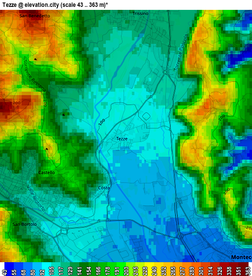
Below is the Elevation map of Tezze, which displays elevation range with different colors. Scale of the first map is from 43 to 363 m (141 to 1191 ft) with average elevation of 144.6 meters (=474 ft) [note 1]
These maps also provides idea of topography and contour of this city, they are displayed at different zoom levels. More info about maps, scale and edge coordinates you can find below images.
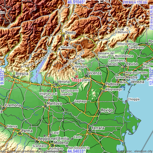
| \ | Map #1 | Topo.Map |
| Scale [m] | 43..363 m | × |
| Scale [ft] | 141..1191 ft | × |
| Average | 144.6 m = 474 ft | × |
| Width | 6.85 km = 4.3 mi | 219.1 km = 136.1 mi |
| Height | 6.85 km = 4.3 mi | 219 km = 136.1 mi |
| ↑Max Latitude | 45.564795° | 46.51045° |
| Latitude at center | 45.53402° | 45.53402° |
| ↓Min Latitude | 45.503229° | 44.54033° |
| ← Min Longitude | 11.326025° | 9.96372° |
| Longitude center | 11.36997° | 11.36997° |
| →Max Longitude | 11.413915° | 12.77622° |
Nearby cities:
Cities around Tezze sort by population:
• Arzignano elevation 117 m
3.2 km,  241°
241°
• Montecchio Maggiore-Alte Ceccato 71 m
4.7 km,  135°
135°
• Chiampo 214 m
6.9 km,  282°
282°
• Trissino 121 m
2.9 km,  10°
10°
• Castelgomberto 141 m
5.6 km,  16°
16°
• Sovizzo 45 m
6 km,  97°
97°
• Brogliano 173 m
6.1 km,  356°
356°
• Montorso Vicentino 86 m
4.9 km,  189°
189°
• Tavernelle 50 m
6.5 km,  109°
109°
• Monteviale 156 m
7.3 km,  67°
67°
• Zermeghedo 62 m
6.5 km,  176°
176°
• Nogarole Vicentino 524 m
7 km,  294°
294°
Multilingual:
 En español:
Tezze elevación 96 m.
 En France:
Tezze élévation 96 m.


Sources and notes:
- [note 1] Map square and city borders are not equal. Map elevation data is calculated only from area inside that square.
- [src 1] Elevation data from geonames database provided with same terms of usage.
- [src 2] The elevation map of Tezze is generated using elevation data from NASA's 3 arcsec (90m) resolution SRTM data.
- [src 3] Base (background) map © OpenStreetMap contributors tiles are generated by Geofabrik and OpenTopoMap.
Copyright & License:
This Tezze Elevation Map is licensed under CC BY-SA. You may reuse any part from this page, if you give a proper credit by linking to this URL:
 More info on terms of use page.