Altissimo elevation
Altissimo (Veneto, Provincia di Vicenza), Italy elevation is 637 meters and Altissimo elevation in feet is 2090 ft above sea level [src 1]. Altissimo is a seat of a third-order administrative division (feature code) with elevation that is 315 meters (1033 ft) bigger than average city elevation in Italy.
Below is the Elevation map of Altissimo, which displays elevation range with different colors. Scale of the first map is from 239 to 918 m (784 to 3012 ft) with average elevation of 580.2 meters (=1904 ft) [note 1]
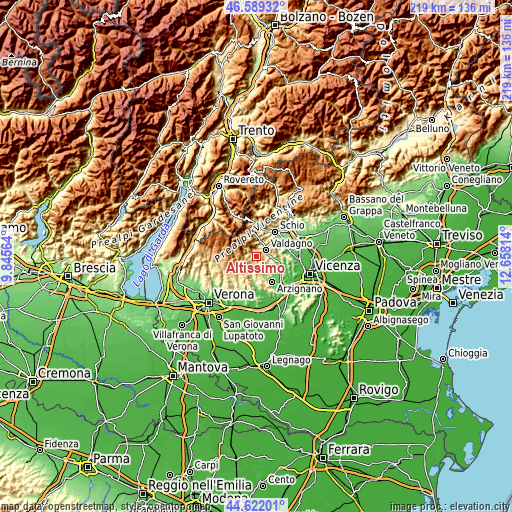
These maps also provides idea of topography and contour of this city, they are displayed at different zoom levels. More info about maps, scale and edge coordinates you can find below images.
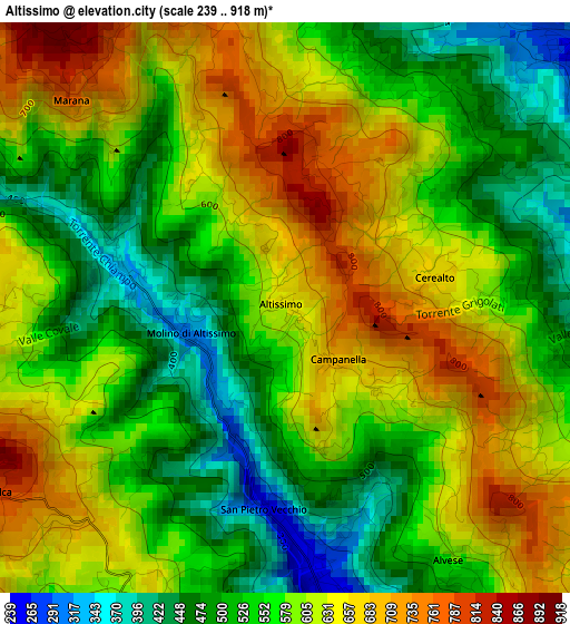
| \ | Map #1 | Topo.Map |
| Scale [m] | 239..918 m | × |
| Scale [ft] | 784..3012 ft | × |
| Average | 580.2 m = 1904 ft | × |
| Width | 6.84 km = 4.3 mi | 218.7 km = 135.9 mi |
| Height | 6.84 km = 4.3 mi | 218.7 km = 135.9 mi |
| ↑Max Latitude | 45.645021° | 46.58932° |
| Latitude at center | 45.61429° | 45.61429° |
| ↓Min Latitude | 45.583542° | 44.62201° |
| ← Min Longitude | 11.207945° | 9.84564° |
| Longitude center | 11.25189° | 11.25189° |
| →Max Longitude | 11.295835° | 12.65814° |
Nearby cities:
Cities around Altissimo sort by population:
• Valdagno elevation 269 m
5 km,  46°
46°
• Chiampo 214 m
7.8 km,  162°
162°
• Cornedo Vicentino 201 m
6.3 km,  87°
87°
• Brogliano 173 m
9.3 km,  107°
107°
• Cereda-Cozza Cornedo 166 m
9.1 km,  98°
98°
• San Quirico 332 m
7.1 km,  13°
13°
• Molino-Mozzi-Bittarelli 320 m
1.3 km,  261°
261°
• San Pietro Mussolino 241 m
3.5 km,  170°
170°
• Vestenanova 491 m
4.8 km,  202°
202°
• Crespadoro 362 m
2.1 km,  287°
287°
• Nogarole Vicentino 524 m
6.6 km,  154°
154°
• Selva di Progno 570 m
8.9 km,  267°
267°
Multilingual:
 En español:
Altissimo elevación 637 m.
 En France:
Altissimo élévation 637 m.
 Auf Deutsch:
Altissimo höhe über dem Meeresspiegel ist 637 m.

Sources and notes:
- [note 1] Map square and city borders are not equal. Map elevation data is calculated only from area inside that square.
- [src 1] Elevation data from geonames database provided with same terms of usage.
- [src 2] The elevation map of Altissimo is generated using elevation data from NASA's 3 arcsec (90m) resolution SRTM data.
- [src 3] Base (background) map © OpenStreetMap contributors tiles are generated by Geofabrik and OpenTopoMap.
Copyright & License:
This Altissimo Elevation Map is licensed under CC BY-SA. You may reuse any part from this page, if you give a proper credit by linking to this URL:
 More info on terms of use page.