Vestenanova elevation
Vestenanova (Veneto, Provincia di Verona), Italy elevation is 491 meters and Vestenanova elevation in feet is 1611 ft above sea level [src 1]. Vestenanova is a seat of a third-order administrative division (feature code) with elevation that is 169 meters (554 ft) bigger than average city elevation in Italy.
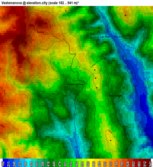
Below is the Elevation map of Vestenanova, which displays elevation range with different colors. Scale of the first map is from 182 to 941 m (597 to 3087 ft) with average elevation of 530.2 meters (=1740 ft) [note 1]
These maps also provides idea of topography and contour of this city, they are displayed at different zoom levels. More info about maps, scale and edge coordinates you can find below images.
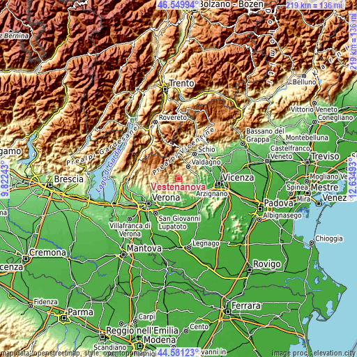
| \ | Map #1 | Topo.Map |
| Scale [m] | 182..941 m | × |
| Scale [ft] | 597..3087 ft | × |
| Average | 530.2 m = 1740 ft | × |
| Width | 6.84 km = 4.3 mi | 218.9 km = 136 mi |
| Height | 6.84 km = 4.3 mi | 218.9 km = 136 mi |
| ↑Max Latitude | 45.604963° | 46.54994° |
| Latitude at center | 45.57421° | 45.57421° |
| ↓Min Latitude | 45.543441° | 44.58123° |
| ← Min Longitude | 11.184735° | 9.82243° |
| Longitude center | 11.22868° | 11.22868° |
| →Max Longitude | 11.272625° | 12.63493° |
Nearby cities:
Cities around Vestenanova sort by population:
• Chiampo elevation 214 m
5.2 km,  125°
125°
• Cornedo Vicentino 201 m
9.3 km,  59°
59°
• Tregnago 314 m
8.4 km,  216°
216°
• San Giovanni Ilarione 168 m
6.1 km,  173°
173°
• Badia Calavena 449 m
6.1 km,  259°
259°
• Molino-Mozzi-Bittarelli 320 m
4.3 km,  6°
6°
• San Pietro Mussolino 241 m
2.6 km,  66°
66°
• Crespadoro 362 m
5.1 km,  357°
357°
• Altissimo 637 m
4.8 km,  22°
22°
• Nogarole Vicentino 524 m
4.9 km,  108°
108°
• San Mauro di Saline 772 m
9.1 km, 263°
• Selva di Progno 570 m
8.2 km,  300°
300°
Multilingual:
 En español:
Vestenanova elevación 491 m.
 En France:
Vestenanova élévation 491 m.
 Auf Deutsch:
Vestenanova höhe über dem Meeresspiegel ist 491 m.

Sources and notes:
- [note 1] Map square and city borders are not equal. Map elevation data is calculated only from area inside that square.
- [src 1] Elevation data from geonames database provided with same terms of usage.
- [src 2] The elevation map of Vestenanova is generated using elevation data from NASA's 3 arcsec (90m) resolution SRTM data.
- [src 3] Base (background) map © OpenStreetMap contributors tiles are generated by Geofabrik and OpenTopoMap.
Copyright & License:
This Vestenanova Elevation Map is licensed under CC BY-SA. You may reuse any part from this page, if you give a proper credit by linking to this URL:
 More info on terms of use page.