Fontanetto Po elevation
Fontanetto Po (Piedmont, Provincia di Vercelli), Italy elevation is 145 meters and Fontanetto Po elevation in feet is 476 ft above sea level [src 1]. Fontanetto Po is a seat of a third-order administrative division (feature code) with elevation that is 177 meters (581 ft) smaller than average city elevation in Italy.
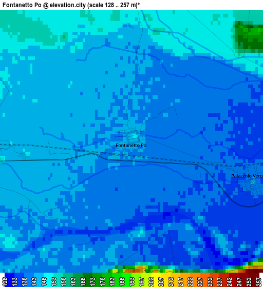
Below is the Elevation map of Fontanetto Po, which displays elevation range with different colors. Scale of the first map is from 128 to 257 m (420 to 843 ft) with average elevation of 143.6 meters (=471 ft) [note 1]
These maps also provides idea of topography and contour of this city, they are displayed at different zoom levels. More info about maps, scale and edge coordinates you can find below images.
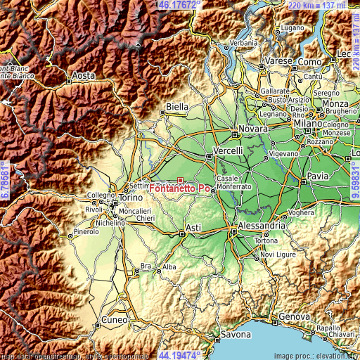
| \ | Map #1 | Topo.Map |
| Scale [m] | 128..257 m | × |
| Scale [ft] | 420..843 ft | × |
| Average | 143.6 m = 471 ft | × |
| Width | 6.89 km = 4.3 mi | 220.4 km = 136.9 mi |
| Height | 6.89 km = 4.3 mi | 220.4 km = 136.9 mi |
| ↑Max Latitude | 45.22532° | 46.17672° |
| Latitude at center | 45.19436° | 45.19436° |
| ↓Min Latitude | 45.163383° | 44.19474° |
| ← Min Longitude | 8.148115° | 6.78581° |
| Longitude center | 8.19206° | 8.19206° |
| →Max Longitude | 8.236005° | 9.59831° |
Nearby cities:
Cities around Fontanetto Po sort by population:
• Trino elevation 136 m
8.2 km,  89°
89°
• Crescentino 162 m
8.3 km,  273°
273°
• Verrua Savoia 288 m
8.9 km,  241°
241°
• Palazzolo Vercellese 141 m
3.4 km,  106°
106°
• Lamporo 167 m
8.4 km,  299°
299°
• Gabiano 281 m
4.1 km,  177°
177°
• Camino 221 m
9 km,  117°
117°
• Cerrina 222 m
8.3 km,  168°
168°
• Valentino 284 m
8.8 km, 240°
• Mombello Monferrato 262 m
8.2 km,  146°
146°
• Moncestino 286 m
5 km,  208°
208°
• Villamiroglio 305 m
6.9 km,  193°
193°
Multilingual:
 En español:
Fontanetto Po elevación 145 m.
 En France:
Fontanetto Po élévation 145 m.
 Auf Deutsch:
Fontanetto Po höhe über dem Meeresspiegel ist 145 m.

Sources and notes:
- [note 1] Map square and city borders are not equal. Map elevation data is calculated only from area inside that square.
- [src 1] Elevation data from geonames database provided with same terms of usage.
- [src 2] The elevation map of Fontanetto Po is generated using elevation data from NASA's 3 arcsec (90m) resolution SRTM data.
- [src 3] Base (background) map © OpenStreetMap contributors tiles are generated by Geofabrik and OpenTopoMap.
Copyright & License:
This Fontanetto Po Elevation Map is licensed under CC BY-SA. You may reuse any part from this page, if you give a proper credit by linking to this URL:
 More info on terms of use page.