Cerrina elevation
Cerrina (Piedmont, Provincia di Alessandria), Italy elevation is 222 meters and Cerrina elevation in feet is 728 ft above sea level [src 1]. Cerrina is a seat of a third-order administrative division (feature code) with elevation that is 100 meters (328 ft) smaller than average city elevation in Italy.
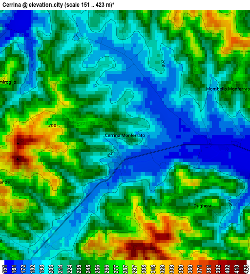
Below is the Elevation map of Cerrina, which displays elevation range with different colors. Scale of the first map is from 151 to 423 m (495 to 1388 ft) with average elevation of 234.5 meters (=769 ft) [note 1]
These maps also provides idea of topography and contour of this city, they are displayed at different zoom levels. More info about maps, scale and edge coordinates you can find below images.
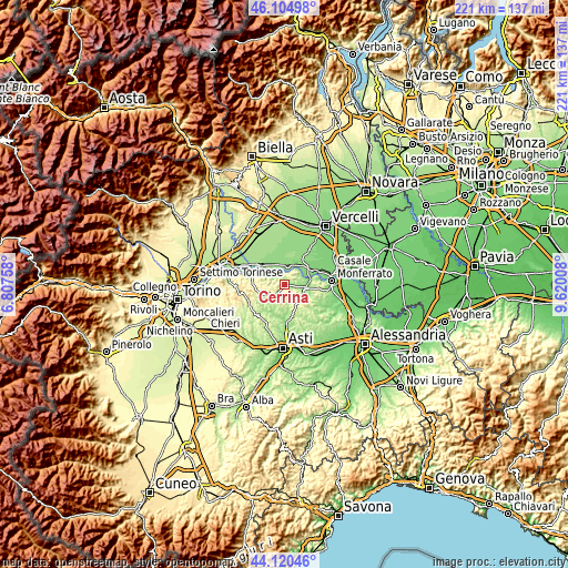
| \ | Map #1 | Topo.Map |
| Scale [m] | 151..423 m | × |
| Scale [ft] | 495..1388 ft | × |
| Average | 234.5 m = 769 ft | × |
| Width | 6.9 km = 4.3 mi | 220.7 km = 137.1 mi |
| Height | 6.9 km = 4.3 mi | 220.6 km = 137.1 mi |
| ↑Max Latitude | 45.15235° | 46.10498° |
| Latitude at center | 45.12135° | 45.12135° |
| ↓Min Latitude | 45.090333° | 44.12046° |
| ← Min Longitude | 8.169885° | 6.80758° |
| Longitude center | 8.21383° | 8.21383° |
| →Max Longitude | 8.257775° | 9.62008° |
Nearby cities:
Cities around Cerrina sort by population:
• Palazzolo Vercellese elevation 141 m
7.3 km,  11°
11°
• Castelletto Merli 267 m
5.7 km,  158°
158°
• Gabiano 281 m
4.3 km,  339°
339°
• Odalengo Piccolo 285 m
5.6 km,  186°
186°
• Villadeati 375 m
6.5 km,  213°
213°
• Mombello Monferrato 262 m
3.1 km,  65°
65°
• Ponzano Monferrato 355 m
5.7 km,  135°
135°
• Serralunga di Crea 242 m
5.7 km,  113°
113°
• Solonghello 182 m
5.5 km,  81°
81°
• Moncestino 286 m
5.5 km,  312°
312°
• Villamiroglio 305 m
3.7 km,  293°
293°
• Odalengo Grande 369 m
3.9 km,  249°
249°
Multilingual:
 En español:
Cerrina elevación 222 m.
 En France:
Cerrina élévation 222 m.


Sources and notes:
- [note 1] Map square and city borders are not equal. Map elevation data is calculated only from area inside that square.
- [src 1] Elevation data from geonames database provided with same terms of usage.
- [src 2] The elevation map of Cerrina is generated using elevation data from NASA's 3 arcsec (90m) resolution SRTM data.
- [src 3] Base (background) map © OpenStreetMap contributors tiles are generated by Geofabrik and OpenTopoMap.
Copyright & License:
This Cerrina Elevation Map is licensed under CC BY-SA. You may reuse any part from this page, if you give a proper credit by linking to this URL:
 More info on terms of use page.