Malo elevation
Malo (Veneto, Provincia di Vicenza), Italy elevation is 113 meters and Malo elevation in feet is 371 ft above sea level [src 1]. Malo is a seat of a third-order administrative division (feature code) with elevation that is 209 meters (686 ft) smaller than average city elevation in Italy.
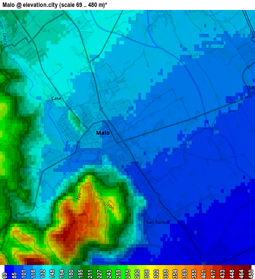
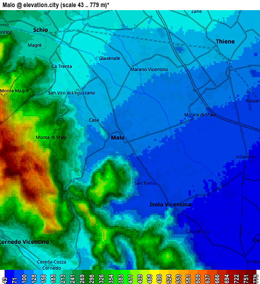
Below is the Elevation map of Malo, which displays elevation range with different colors. Scale of the first map is from 69 to 480 m (226 to 1575 ft) with average elevation of 143.9 meters (=472 ft) [note 1]
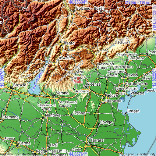
These maps also provides idea of topography and contour of this city, they are displayed at different zoom levels. More info about maps, scale and edge coordinates you can find below images.
| \ | Map #1 | Map #2 | Topo.Map |
| Scale [m] | 69..480 m | 43..779 m | × |
| Scale [ft] | 226..1575 ft | 141..2556 ft | × |
| Average | 143.9 m = 472 ft | 194.2 m = 637 ft | × |
| Width | 6.83 km = 4.2 mi | 13.66 km = 8.5 mi | 218.6 km = 135.8 mi |
| Height | 6.83 km = 4.2 mi | 13.66 km = 8.5 mi | 218.6 km = 135.8 mi |
| ↑Max Latitude | 45.689806° | 45.720495° | 46.63334° |
| Latitude at center | 45.6591° | 45.6591° | 45.6591° |
| ↓Min Latitude | 45.628377° | 45.597637° | 44.66761° |
| ← Min Longitude | 11.372065° | 11.328119° | 10.00976° |
| Longitude center | 11.41601° | 11.41601° | 11.41601° |
| →Max Longitude | 11.459955° | 11.503901° | 12.82226° |
Nearby cities:
Cities around Malo sort by population:
• Schio elevation 199 m
7.5 km,  322°
322°
• Thiene 151 m
7.4 km,  41°
41°
• Marano Vicentino 137 m
4.3 km,  17°
17°
• Zanè 173 m
7.5 km, 20°
• Villaverla 71 m
6 km,  100°
100°
• Isola Vicentina 75 m
4.1 km,  144°
144°
• Castelnovo 65 m
5.9 km,  145°
145°
• San Vito di Leguzzano 153 m
3.6 km, 323°
• Cereda-Cozza Cornedo 166 m
7.4 km,  210°
210°
• Novoledo 61 m
7.4 km, 100°
• Giavenale 156 m
4.7 km,  344°
344°
• Monte di Malo 377 m
4.3 km,  271°
271°
Multilingual:
 En español:
Malo elevación 113 m.
 En France:
Malo élévation 113 m.


Sources and notes:
- [note 1] Map square and city borders are not equal. Map elevation data is calculated only from area inside that square.
- [src 1] Elevation data from geonames database provided with same terms of usage.
- [src 2] The elevation map of Malo is generated using elevation data from NASA's 3 arcsec (90m) resolution SRTM data.
- [src 3] Base (background) map © OpenStreetMap contributors tiles are generated by Geofabrik and OpenTopoMap.
Copyright & License:
This Malo Elevation Map is licensed under CC BY-SA. You may reuse any part from this page, if you give a proper credit by linking to this URL:
 More info on terms of use page.