Zanè elevation
Zanè (Veneto, Provincia di Vicenza), Italy elevation is 173 meters and Zanè elevation in feet is 568 ft above sea level [src 1]. Zanè is a seat of a third-order administrative division (feature code) with elevation that is 149 meters (489 ft) smaller than average city elevation in Italy.
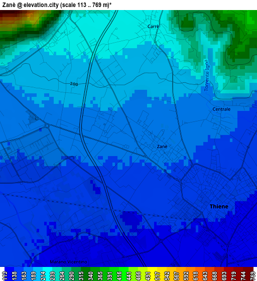
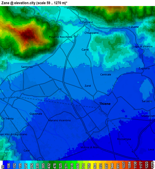
Below is the Elevation map of Zanè, which displays elevation range with different colors. Scale of the first map is from 113 to 769 m (371 to 2523 ft) with average elevation of 186.3 meters (=611 ft) [note 1]
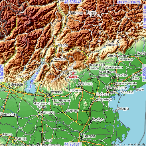
These maps also provides idea of topography and contour of this city, they are displayed at different zoom levels. More info about maps, scale and edge coordinates you can find below images.
| \ | Map #1 | Map #2 | Topo.Map |
| Scale [m] | 113..769 m | 59..1270 m | × |
| Scale [ft] | 371..2523 ft | 194..4167 ft | × |
| Average | 186.3 m = 611 ft | 239.3 m = 785 ft | × |
| Width | 6.82 km = 4.2 mi | 13.65 km = 8.5 mi | 218.3 km = 135.6 mi |
| Height | 6.82 km = 4.2 mi | 13.65 km = 8.5 mi | 218.3 km = 135.6 mi |
| ↑Max Latitude | 45.752672° | 45.783326° | 46.69514° |
| Latitude at center | 45.722° | 45.722° | 45.722° |
| ↓Min Latitude | 45.691312° | 45.660606° | 44.73161° |
| ← Min Longitude | 11.405375° | 11.361429° | 10.04307° |
| Longitude center | 11.44932° | 11.44932° | 11.44932° |
| →Max Longitude | 11.493265° | 11.537211° | 12.85557° |
Nearby cities:
Cities around Zanè sort by population:
• Thiene elevation 151 m
2.8 km,  121°
121°
• Marano Vicentino 137 m
3.2 km,  204°
204°
• Piovene Rocchette 253 m
4 km,  341°
341°
• Santorso 206 m
4.9 km,  285°
285°
• San Vito di Leguzzano 153 m
6.3 km,  228°
228°
• Zugliano 145 m
5.9 km,  81°
81°
• Carrè 224 m
3.1 km,  12°
12°
• Chiuppano 245 m
4.6 km, 8°
• Caltrano 253 m
5.7 km,  4°
4°
• Centrale 176 m
2.5 km, 76°
• Giavenale 156 m
4.5 km,  237°
237°
• Grumolo Pedemonte 154 m
3.4 km,  85°
85°
Multilingual:
 En español:
Zanè elevación 173 m.
 En France:
Zanè élévation 173 m.


Sources and notes:
- [note 1] Map square and city borders are not equal. Map elevation data is calculated only from area inside that square.
- [src 1] Elevation data from geonames database provided with same terms of usage.
- [src 2] The elevation map of Zanè is generated using elevation data from NASA's 3 arcsec (90m) resolution SRTM data.
- [src 3] Base (background) map © OpenStreetMap contributors tiles are generated by Geofabrik and OpenTopoMap.
Copyright & License:
This Zanè Elevation Map is licensed under CC BY-SA. You may reuse any part from this page, if you give a proper credit by linking to this URL:
 More info on terms of use page.