Santorso elevation
Santorso (Veneto, Provincia di Vicenza), Italy elevation is 206 meters and Santorso elevation in feet is 676 ft above sea level [src 1]. Santorso is a seat of a third-order administrative division (feature code) with elevation that is 116 meters (381 ft) smaller than average city elevation in Italy.
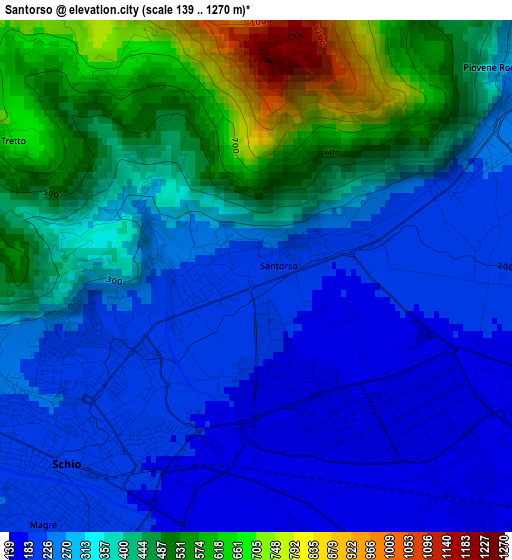
Below is the Elevation map of Santorso, which displays elevation range with different colors. Scale of the first map is from 139 to 1270 m (456 to 4167 ft) with average elevation of 349.6 meters (=1147 ft) [note 1]
These maps also provides idea of topography and contour of this city, they are displayed at different zoom levels. More info about maps, scale and edge coordinates you can find below images.
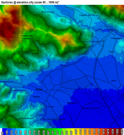
| \ | Map #1 | Map #2 | Topo.Map |
| Scale [m] | 139..1270 m | 95..1659 m | × |
| Scale [ft] | 456..4167 ft | 312..5443 ft | × |
| Average | 349.6 m = 1147 ft | 411.9 m = 1351 ft | × |
| Width | 6.82 km = 4.2 mi | 13.64 km = 8.5 mi | 218.3 km = 135.6 mi |
| Height | 6.82 km = 4.2 mi | 13.64 km = 8.5 mi | 218.3 km = 135.6 mi |
| ↑Max Latitude | 45.764495° | 45.795143° | 46.70676° |
| Latitude at center | 45.73383° | 45.73383° | 45.73383° |
| ↓Min Latitude | 45.703148° | 45.672449° | 44.74365° |
| ← Min Longitude | 11.343905° | 11.299959° | 9.9816° |
| Longitude center | 11.38785° | 11.38785° | 11.38785° |
| →Max Longitude | 11.431795° | 11.475741° | 12.7941° |
Nearby cities:
Cities around Santorso sort by population:
• Schio elevation 199 m
3.4 km,  225°
225°
• Marano Vicentino 137 m
5.4 km,  140°
140°
• Piovene Rocchette 253 m
4.3 km,  54°
54°
• Zanè 173 m
4.9 km,  105°
105°
• Torrebelvicino 245 m
5.7 km,  249°
249°
• San Vito di Leguzzano 153 m
5.4 km,  179°
179°
• Carrè 224 m
5.7 km,  72°
72°
• Cogollo del Cengio 299 m
6.3 km,  27°
27°
• Chiuppano 245 m
6.3 km,  59°
59°
• Velo d'Astico 347 m
6.3 km,  345°
345°
• Giavenale 156 m
3.9 km,  165°
165°
• Velo 327 m
6.4 km, 345°
Multilingual:
 En español:
Santorso elevación 206 m.
 En France:
Santorso élévation 206 m.
 Auf Deutsch:
Santorso höhe über dem Meeresspiegel ist 206 m.

Sources and notes:
- [note 1] Map square and city borders are not equal. Map elevation data is calculated only from area inside that square.
- [src 1] Elevation data from geonames database provided with same terms of usage.
- [src 2] The elevation map of Santorso is generated using elevation data from NASA's 3 arcsec (90m) resolution SRTM data.
- [src 3] Base (background) map © OpenStreetMap contributors tiles are generated by Geofabrik and OpenTopoMap.
Copyright & License:
This Santorso Elevation Map is licensed under CC BY-SA. You may reuse any part from this page, if you give a proper credit by linking to this URL:
 More info on terms of use page.