Monte di Malo elevation
Monte di Malo (Veneto, Provincia di Vicenza), Italy elevation is 377 meters and Monte di Malo elevation in feet is 1237 ft above sea level [src 1]. Monte di Malo is a seat of a third-order administrative division (feature code) with elevation that is 55 meters (180 ft) bigger than average city elevation in Italy.
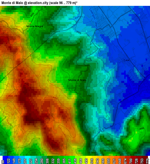
Below is the Elevation map of Monte di Malo, which displays elevation range with different colors. Scale of the first map is from 96 to 779 m (315 to 2556 ft) with average elevation of 365.2 meters (=1198 ft) [note 1]
These maps also provides idea of topography and contour of this city, they are displayed at different zoom levels. More info about maps, scale and edge coordinates you can find below images.
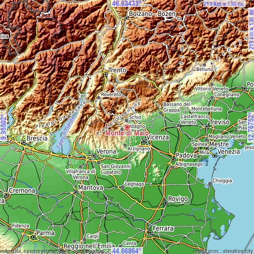
| \ | Map #1 | Topo.Map |
| Scale [m] | 96..779 m | × |
| Scale [ft] | 315..2556 ft | × |
| Average | 365.2 m = 1198 ft | × |
| Width | 6.83 km = 4.2 mi | 218.6 km = 135.8 mi |
| Height | 6.83 km = 4.2 mi | 218.6 km = 135.8 mi |
| ↑Max Latitude | 45.690816° | 46.63433° |
| Latitude at center | 45.66011° | 45.66011° |
| ↓Min Latitude | 45.629388° | 44.66864° |
| ← Min Longitude | 11.317325° | 9.95502° |
| Longitude center | 11.36127° | 11.36127° |
| →Max Longitude | 11.405215° | 12.76752° |
Nearby cities:
Cities around Monte di Malo sort by population:
• Schio elevation 199 m
5.8 km,  356°
356°
• Valdagno 269 m
5.1 km,  250°
250°
• Malo 113 m
4.3 km,  91°
91°
• Marano Vicentino 137 m
6.8 km,  54°
54°
• Cornedo Vicentino 201 m
5.4 km,  204°
204°
• Torrebelvicino 245 m
7 km,  331°
331°
• Isola Vicentina 75 m
7.4 km,  117°
117°
• San Vito di Leguzzano 153 m
3.5 km,  37°
37°
• Brogliano 173 m
7.9 km,  177°
177°
• Cereda-Cozza Cornedo 166 m
6.5 km, 175°
• San Quirico 332 m
7.1 km,  285°
285°
• Giavenale 156 m
5.4 km,  34°
34°
Multilingual:
 En español:
Monte di Malo elevación 377 m.
 En France:
Monte di Malo élévation 377 m.
 Auf Deutsch:
Monte di Malo höhe über dem Meeresspiegel ist 377 m.

Sources and notes:
- [note 1] Map square and city borders are not equal. Map elevation data is calculated only from area inside that square.
- [src 1] Elevation data from geonames database provided with same terms of usage.
- [src 2] The elevation map of Monte di Malo is generated using elevation data from NASA's 3 arcsec (90m) resolution SRTM data.
- [src 3] Base (background) map © OpenStreetMap contributors tiles are generated by Geofabrik and OpenTopoMap.
Copyright & License:
This Monte di Malo Elevation Map is licensed under CC BY-SA. You may reuse any part from this page, if you give a proper credit by linking to this URL:
 More info on terms of use page.