San Piero a Sieve elevation
San Piero a Sieve (Tuscany, Province of Florence), Italy elevation is 215 meters and San Piero a Sieve elevation in feet is 705 ft above sea level [src 1]. San Piero a Sieve is a seat of a third-order administrative division (feature code) with elevation that is 107 meters (351 ft) smaller than average city elevation in Italy.
Below is the Elevation map of San Piero a Sieve, which displays elevation range with different colors. Scale of the first map is from 189 to 563 m (620 to 1847 ft) with average elevation of 264.1 meters (=866 ft) [note 1]
These maps also provides idea of topography and contour of this city, they are displayed at different zoom levels. More info about maps, scale and edge coordinates you can find below images.
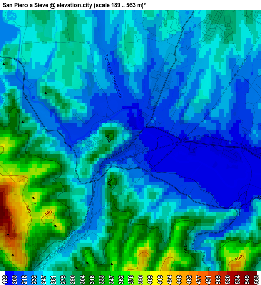
| \ | Map #1 | Topo.Map |
| Scale [m] | 189..563 m | × |
| Scale [ft] | 620..1847 ft | × |
| Average | 264.1 m = 866 ft | × |
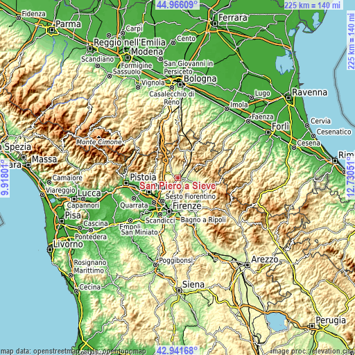
| Width | 7.03 km = 4.4 mi | 225.1 km = 139.9 mi |
| Height | 7.03 km = 4.4 mi | 225.1 km = 139.9 mi |
| ↑Max Latitude | 43.994133° | 44.96609° |
| Latitude at center | 43.96251° | 43.96251° |
| ↓Min Latitude | 43.93087° | 42.94168° |
| ← Min Longitude | 11.280315° | 9.91801° |
| Longitude center | 11.32426° | 11.32426° |
| →Max Longitude | 11.368205° | 12.73051° |
Nearby cities:
Cities around San Piero a Sieve sort by population:
• Borgo San Lorenzo elevation 193 m
5 km,  99°
99°
• Vaiano 169 m
16.1 km,  272°
272°
• Barberino di Mugello 290 m
8.1 km,  300°
300°
• Scarperia 287 m
4.2 km,  34°
34°
• Vicchio 186 m
11.3 km,  106°
106°
• Caldine 146 m
15 km,  186°
186°
• Cavallina 273 m
7.8 km,  287°
287°
• Luco Mugello 305 m
7.1 km,  53°
53°
• Ronta 358 m
9.5 km,  61°
61°
• Carraia 107 m
13.6 km,  236°
236°
• Galliano 301 m
6.6 km,  338°
338°
• Vaglia 281 m
6.8 km,  211°
211°
Multilingual:
 En español:
San Piero a Sieve elevación 215 m.
 En France:
San Piero a Sieve élévation 215 m.
 Auf Deutsch:
San Piero a Sieve höhe über dem Meeresspiegel ist 215 m.

Sources and notes:
- [note 1] Map square and city borders are not equal. Map elevation data is calculated only from area inside that square.
- [src 1] Elevation data from geonames database provided with same terms of usage.
- [src 2] The elevation map of San Piero a Sieve is generated using elevation data from NASA's 3 arcsec (90m) resolution SRTM data.
- [src 3] Base (background) map © OpenStreetMap contributors tiles are generated by Geofabrik and OpenTopoMap.
Copyright & License:
This San Piero a Sieve Elevation Map is licensed under CC BY-SA. You may reuse any part from this page, if you give a proper credit by linking to this URL:
 More info on terms of use page.