Carraia elevation
Carraia (Tuscany, Province of Florence), Italy elevation is 107 meters and Carraia elevation in feet is 351 ft above sea level [src 1]. Carraia is a populated place (feature code) with elevation that is 215 meters (705 ft) smaller than average city elevation in Italy.
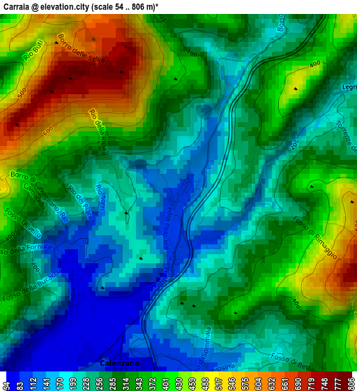
Below is the Elevation map of Carraia, which displays elevation range with different colors. Scale of the first map is from 54 to 806 m (177 to 2644 ft) with average elevation of 302.8 meters (=993 ft) [note 1]
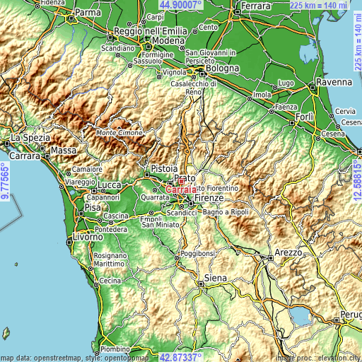
These maps also provides idea of topography and contour of this city, they are displayed at different zoom levels. More info about maps, scale and edge coordinates you can find below images.
| \ | Map #1 | Topo.Map |
| Scale [m] | 54..806 m | × |
| Scale [ft] | 177..2644 ft | × |
| Average | 302.8 m = 993 ft | × |
| Width | 7.04 km = 4.4 mi | 225.3 km = 140 mi |
| Height | 7.04 km = 4.4 mi | 225.3 km = 140 mi |
| ↑Max Latitude | 43.926999° | 44.90007° |
| Latitude at center | 43.89534° | 43.89534° |
| ↓Min Latitude | 43.863664° | 42.87337° |
| ← Min Longitude | 11.137955° | 9.77565° |
| Longitude center | 11.1819° | 11.1819° |
| →Max Longitude | 11.225845° | 12.58815° |
Nearby cities:
Cities around Carraia sort by population:
• Prato elevation 71 m
7 km,  256°
256°
• Sesto Fiorentino 60 m
7.2 km,  168°
168°
• Campi Bisenzio 38 m
8.9 km,  207°
207°
• Montemurlo 78 m
12.1 km,  286°
286°
• Fornacelle 68 m
12.2 km, 285°
• Calenzano 56 m
4.7 km,  195°
195°
• Vaiano 169 m
9.3 km,  330°
330°
• San Donnino 37 m
11.5 km,  194°
194°
• San Mauro 37 m
12.1 km, 202°
• Caldine 146 m
12.3 km,  127°
127°
• Cavallina 273 m
10.6 km,  22°
22°
• Vaglia 281 m
8 km,  77°
77°
Multilingual:
 En español:
Carraia elevación 107 m.
 En France:
Carraia élévation 107 m.


Sources and notes:
- [note 1] Map square and city borders are not equal. Map elevation data is calculated only from area inside that square.
- [src 1] Elevation data from geonames database provided with same terms of usage.
- [src 2] The elevation map of Carraia is generated using elevation data from NASA's 3 arcsec (90m) resolution SRTM data.
- [src 3] Base (background) map © OpenStreetMap contributors tiles are generated by Geofabrik and OpenTopoMap.
Copyright & License:
This Carraia Elevation Map is licensed under CC BY-SA. You may reuse any part from this page, if you give a proper credit by linking to this URL:
 More info on terms of use page.