Vaglia elevation
Vaglia (Tuscany, Province of Florence), Italy elevation is 281 meters and Vaglia elevation in feet is 922 ft above sea level [src 1]. Vaglia is a seat of a third-order administrative division (feature code) with elevation that is 41 meters (135 ft) smaller than average city elevation in Italy.
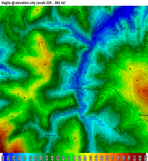
Below is the Elevation map of Vaglia, which displays elevation range with different colors. Scale of the first map is from 229 to 862 m (751 to 2828 ft) with average elevation of 444.3 meters (=1458 ft) [note 1]
These maps also provides idea of topography and contour of this city, they are displayed at different zoom levels. More info about maps, scale and edge coordinates you can find below images.
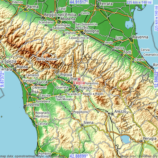
| \ | Map #1 | Topo.Map |
| Scale [m] | 229..862 m | × |
| Scale [ft] | 751..2828 ft | × |
| Average | 444.3 m = 1458 ft | × |
| Width | 7.04 km = 4.4 mi | 225.3 km = 140 mi |
| Height | 7.04 km = 4.4 mi | 225.3 km = 140 mi |
| ↑Max Latitude | 43.942351° | 44.91517° |
| Latitude at center | 43.9107° | 43.9107° |
| ↓Min Latitude | 43.879032° | 42.88899° |
| ← Min Longitude | 11.236025° | 9.87372° |
| Longitude center | 11.27997° | 11.27997° |
| →Max Longitude | 11.323915° | 12.68622° |
Nearby cities:
Cities around Vaglia sort by population:
• Sesto Fiorentino elevation 60 m
10.9 km,  216°
216°
• Calenzano 56 m
11.1 km,  235°
235°
• Borgo San Lorenzo 193 m
9.8 km,  59°
59°
• Barberino di Mugello 290 m
10.4 km,  340°
340°
• Scarperia 287 m
11 km,  32°
32°
• San Piero a Sieve 215 m
6.8 km, 31°
• Fiesole 312 m
11.9 km,  174°
174°
• Caldine 146 m
9.4 km, 167°
• Cavallina 273 m
9 km,  334°
334°
• Carraia 107 m
8 km,  257°
257°
• Pian di Mugnone 138 m
10.4 km, 172°
• Galliano 301 m
11.9 km,  5°
5°
Multilingual:
 En español:
Vaglia elevación 281 m.
 En France:
Vaglia élévation 281 m.


Sources and notes:
- [note 1] Map square and city borders are not equal. Map elevation data is calculated only from area inside that square.
- [src 1] Elevation data from geonames database provided with same terms of usage.
- [src 2] The elevation map of Vaglia is generated using elevation data from NASA's 3 arcsec (90m) resolution SRTM data.
- [src 3] Base (background) map © OpenStreetMap contributors tiles are generated by Geofabrik and OpenTopoMap.
Copyright & License:
This Vaglia Elevation Map is licensed under CC BY-SA. You may reuse any part from this page, if you give a proper credit by linking to this URL:
 More info on terms of use page.