Ronta elevation
Ronta (Tuscany, Province of Florence), Italy elevation is 358 meters and Ronta elevation in feet is 1175 ft above sea level [src 1]. Ronta is a populated place (feature code) with elevation that is 36 meters (118 ft) bigger than average city elevation in Italy.
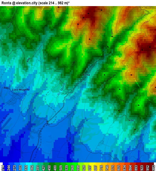
Below is the Elevation map of Ronta, which displays elevation range with different colors. Scale of the first map is from 214 to 982 m (702 to 3222 ft) with average elevation of 451.5 meters (=1481 ft) [note 1]
These maps also provides idea of topography and contour of this city, they are displayed at different zoom levels. More info about maps, scale and edge coordinates you can find below images.
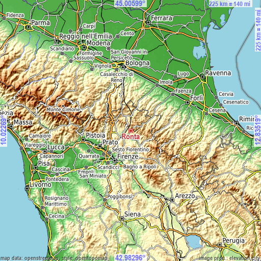
| \ | Map #1 | Topo.Map |
| Scale [m] | 214..982 m | × |
| Scale [ft] | 702..3222 ft | × |
| Average | 451.5 m = 1481 ft | × |
| Width | 7.03 km = 4.4 mi | 224.9 km = 139.7 mi |
| Height | 7.03 km = 4.4 mi | 224.9 km = 139.7 mi |
| ↑Max Latitude | 44.034702° | 45.00599° |
| Latitude at center | 44.0031° | 44.0031° |
| ↓Min Latitude | 43.971482° | 42.98296° |
| ← Min Longitude | 11.384995° | 10.02269° |
| Longitude center | 11.42894° | 11.42894° |
| →Max Longitude | 11.472885° | 12.83519° |
Nearby cities:
Cities around Ronta sort by population:
• Borgo San Lorenzo elevation 193 m
6.3 km,  213°
213°
• Barberino di Mugello 290 m
15.4 km,  268°
268°
• Scarperia 287 m
6.1 km,  259°
259°
• Vicchio 186 m
8.1 km,  162°
162°
• Dicomano 163 m
14.4 km,  148°
148°
• San Piero a Sieve 215 m
9.5 km,  241°
241°
• Firenzuola 426 m
13.5 km,  343°
343°
• Cavallina 273 m
15.9 km, 262°
• Luco Mugello 305 m
2.6 km, 263°
• Galliano 301 m
10.9 km,  278°
278°
• Vaglia 281 m
15.7 km,  229°
229°
• Palazzuolo sul Senio 462 m
15.2 km,  36°
36°
Multilingual:
 En español:
Ronta elevación 358 m.
 En France:
Ronta élévation 358 m.


Sources and notes:
- [note 1] Map square and city borders are not equal. Map elevation data is calculated only from area inside that square.
- [src 1] Elevation data from geonames database provided with same terms of usage.
- [src 2] The elevation map of Ronta is generated using elevation data from NASA's 3 arcsec (90m) resolution SRTM data.
- [src 3] Base (background) map © OpenStreetMap contributors tiles are generated by Geofabrik and OpenTopoMap.
Copyright & License:
This Ronta Elevation Map is licensed under CC BY-SA. You may reuse any part from this page, if you give a proper credit by linking to this URL:
 More info on terms of use page.