Sant'Angelo in Vado elevation
Sant'Angelo in Vado (The Marches, Provincia di Pesaro e Urbino), Italy elevation is 350 meters and Sant'Angelo in Vado elevation in feet is 1148 ft above sea level [src 1]. Sant'Angelo in Vado is a seat of a third-order administrative division (feature code) with elevation that is 28 meters (92 ft) bigger than average city elevation in Italy.
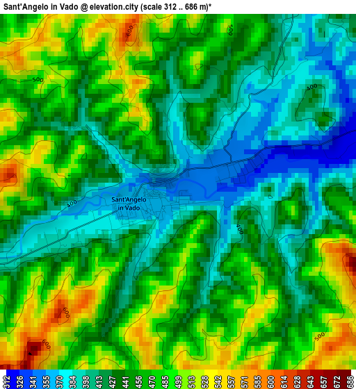
Below is the Elevation map of Sant'Angelo in Vado, which displays elevation range with different colors. Scale of the first map is from 312 to 686 m (1024 to 2251 ft) with average elevation of 448.8 meters (=1472 ft) [note 1]
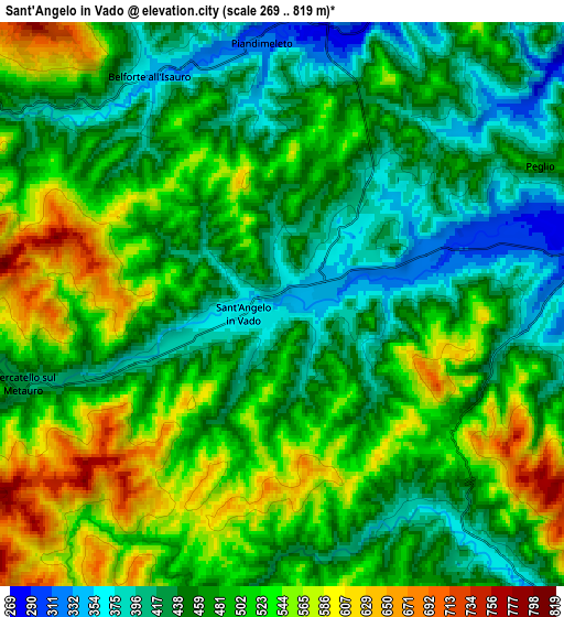
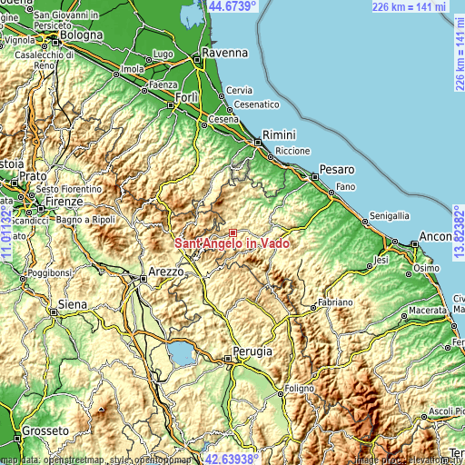
These maps also provides idea of topography and contour of this city, they are displayed at different zoom levels. More info about maps, scale and edge coordinates you can find below images.
| \ | Map #1 | Map #2 | Topo.Map |
| Scale [m] | 312..686 m | 269..819 m | × |
| Scale [ft] | 1024..2251 ft | 883..2687 ft | × |
| Average | 448.8 m = 1472 ft | 484.4 m = 1589 ft | × |
| Width | 7.07 km = 4.4 mi | 14.14 km = 8.8 mi | 226.2 km = 140.6 mi |
| Height | 7.07 km = 4.4 mi | 14.14 km = 8.8 mi | 226.2 km = 140.6 mi |
| ↑Max Latitude | 43.697041° | 43.728805° | 44.6739° |
| Latitude at center | 43.66526° | 43.66526° | 43.66526° |
| ↓Min Latitude | 43.633462° | 43.601647° | 42.63938° |
| ← Min Longitude | 12.373625° | 12.329679° | 11.01132° |
| Longitude center | 12.41757° | 12.41757° | 12.41757° |
| →Max Longitude | 12.461515° | 12.505461° | 13.82382° |
Nearby cities:
Cities around Sant'Angelo in Vado sort by population:
• Urbania elevation 280 m
8.3 km,  87°
87°
• Piobbico 338 m
11.3 km,  139°
139°
• Piandimeleto 325 m
6.5 km,  353°
353°
• Lunano 276 m
7.7 km,  15°
15°
• Mercatello sul Metauro 430 m
6.9 km,  252°
252°
• Apecchio 478 m
11.8 km,  178°
178°
• Mercatale 237 m
14.1 km, 22°
• Sestino 506 m
10.8 km,  297°
297°
• Belforte 346 m
6.6 km,  329°
329°
• Peglio 473 m
7.3 km,  61°
61°
• Borgo Pace 471 m
10 km,  265°
265°
• Frontino 508 m
11.5 km,  343°
343°
Multilingual:
 En español:
Sant'Angelo in Vado elevación 350 m.
 En France:
Sant'Angelo in Vado élévation 350 m.
 Auf Deutsch:
Sant'Angelo in Vado höhe über dem Meeresspiegel ist 350 m.
 На русском:
Sant'Angelo in Vado высота над уровнем моря 350 м
Sources and notes:
- [note 1] Map square and city borders are not equal. Map elevation data is calculated only from area inside that square.
- [src 1] Elevation data from geonames database provided with same terms of usage.
- [src 2] The elevation map of Sant'Angelo in Vado is generated using elevation data from NASA's 3 arcsec (90m) resolution SRTM data.
- [src 3] Base (background) map © OpenStreetMap contributors tiles are generated by Geofabrik and OpenTopoMap.
Copyright & License:
This Sant'Angelo in Vado Elevation Map is licensed under CC BY-SA. You may reuse any part from this page, if you give a proper credit by linking to this URL:
 More info on terms of use page.