Belforte elevation
Belforte (The Marches, Provincia di Pesaro e Urbino), Italy elevation is 346 meters and Belforte elevation in feet is 1135 ft above sea level [src 1]. Belforte is a seat of a third-order administrative division (feature code) with elevation that is 24 meters (79 ft) bigger than average city elevation in Italy.
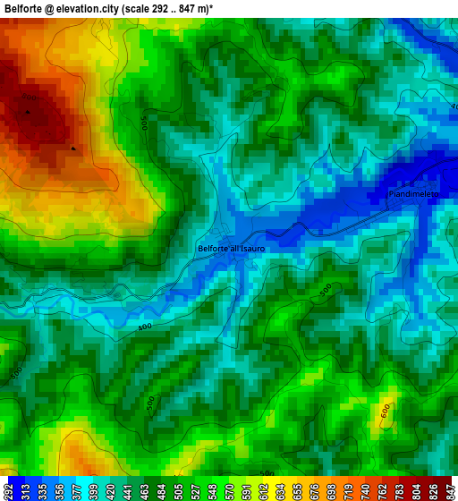
Below is the Elevation map of Belforte, which displays elevation range with different colors. Scale of the first map is from 292 to 847 m (958 to 2779 ft) with average elevation of 487.8 meters (=1600 ft) [note 1]
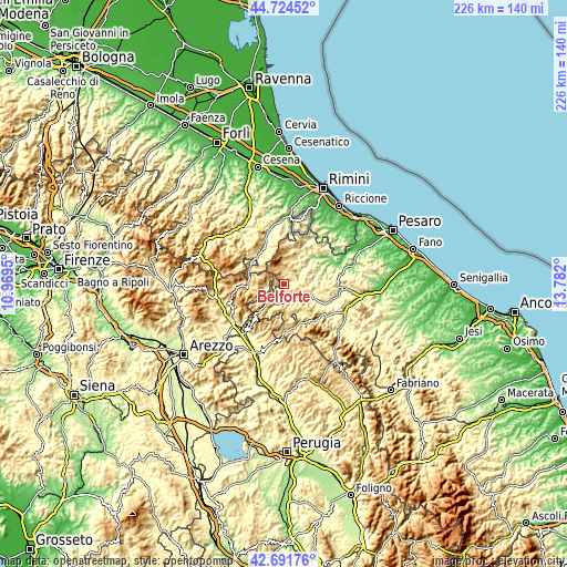
These maps also provides idea of topography and contour of this city, they are displayed at different zoom levels. More info about maps, scale and edge coordinates you can find below images.
| \ | Map #1 | Topo.Map |
| Scale [m] | 292..847 m | × |
| Scale [ft] | 958..2779 ft | × |
| Average | 487.8 m = 1600 ft | × |
| Width | 7.06 km = 4.4 mi | 226 km = 140.4 mi |
| Height | 7.06 km = 4.4 mi | 226 km = 140.4 mi |
| ↑Max Latitude | 43.748514° | 44.72452° |
| Latitude at center | 43.71676° | 43.71676° |
| ↓Min Latitude | 43.684989° | 42.69176° |
| ← Min Longitude | 12.331805° | 10.9695° |
| Longitude center | 12.37575° | 12.37575° |
| →Max Longitude | 12.419695° | 13.782° |
Nearby cities:
Cities around Belforte sort by population:
• Sant'Angelo in Vado elevation 350 m
6.6 km,  149°
149°
• Piandimeleto 325 m
2.7 km,  74°
74°
• Macerata Feltria 312 m
11 km,  29°
29°
• Carpegna 747 m
7.9 km,  335°
335°
• Lunano 276 m
5.7 km, 72°
• Mercatello sul Metauro 430 m
8.4 km,  202°
202°
• Mercatale 237 m
11.4 km,  50°
50°
• Sestino 506 m
6.3 km,  262°
262°
• Peglio 473 m
10.1 km,  102°
102°
• Borgo Pace 471 m
9.3 km,  225°
225°
• Mercato Vecchio 588 m
9.7 km,  0°
0°
• Frontino 508 m
5.3 km, 0°
Multilingual:
 En español:
Belforte elevación 346 m.
 En France:
Belforte all'Isauro élévation 346 m.
 Auf Deutsch:
Belforte höhe über dem Meeresspiegel ist 346 m.

Sources and notes:
- [note 1] Map square and city borders are not equal. Map elevation data is calculated only from area inside that square.
- [src 1] Elevation data from geonames database provided with same terms of usage.
- [src 2] The elevation map of Belforte is generated using elevation data from NASA's 3 arcsec (90m) resolution SRTM data.
- [src 3] Base (background) map © OpenStreetMap contributors tiles are generated by Geofabrik and OpenTopoMap.
Copyright & License:
This Belforte Elevation Map is licensed under CC BY-SA. You may reuse any part from this page, if you give a proper credit by linking to this URL:
 More info on terms of use page.