Sestino elevation
Sestino (Tuscany, Province of Arezzo), Italy elevation is 506 meters and Sestino elevation in feet is 1660 ft above sea level [src 1]. Sestino is a seat of a third-order administrative division (feature code) with elevation that is 184 meters (604 ft) bigger than average city elevation in Italy.
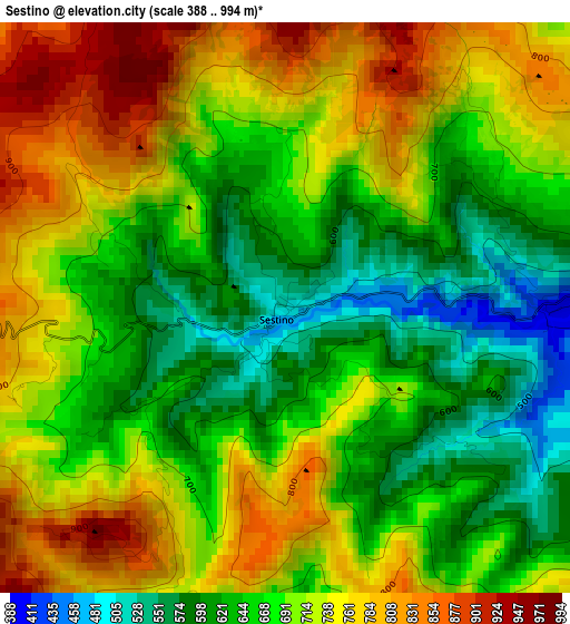
Below is the Elevation map of Sestino, which displays elevation range with different colors. Scale of the first map is from 388 to 994 m (1273 to 3261 ft) with average elevation of 694 meters (=2277 ft) [note 1]
These maps also provides idea of topography and contour of this city, they are displayed at different zoom levels. More info about maps, scale and edge coordinates you can find below images.
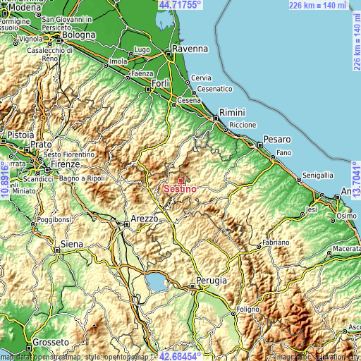
| \ | Map #1 | Topo.Map |
| Scale [m] | 388..994 m | × |
| Scale [ft] | 1273..3261 ft | × |
| Average | 694 m = 2277 ft | × |
| Width | 7.06 km = 4.4 mi | 226 km = 140.4 mi |
| Height | 7.06 km = 4.4 mi | 226 km = 140.4 mi |
| ↑Max Latitude | 43.741417° | 44.71755° |
| Latitude at center | 43.70966° | 43.70966° |
| ↓Min Latitude | 43.677886° | 42.68454° |
| ← Min Longitude | 12.253905° | 10.8916° |
| Longitude center | 12.29785° | 12.29785° |
| →Max Longitude | 12.341795° | 13.7041° |
Nearby cities:
Cities around Sestino sort by population:
• Sant'Angelo in Vado elevation 350 m
10.8 km,  117°
117°
• Piandimeleto 325 m
9 km,  80°
80°
• Carpegna 747 m
8.5 km,  20°
20°
• Lunano 276 m
11.9 km, 77°
• Mercatello sul Metauro 430 m
7.6 km,  156°
156°
• Pennabilli 580 m
12.2 km,  348°
348°
• Belforte 346 m
6.3 km, 82°
• Casteldelci 582 m
14.6 km,  308°
308°
• Badia Tedalda 699 m
9.1 km,  269°
269°
• Borgo Pace 471 m
5.7 km,  183°
183°
• Mercato Vecchio 588 m
12.3 km,  31°
31°
• Frontino 508 m
8.8 km,  46°
46°
Multilingual:
 En español:
Sestino elevación 506 m.
 En France:
Sestino élévation 506 m.


Sources and notes:
- [note 1] Map square and city borders are not equal. Map elevation data is calculated only from area inside that square.
- [src 1] Elevation data from geonames database provided with same terms of usage.
- [src 2] The elevation map of Sestino is generated using elevation data from NASA's 3 arcsec (90m) resolution SRTM data.
- [src 3] Base (background) map © OpenStreetMap contributors tiles are generated by Geofabrik and OpenTopoMap.
Copyright & License:
This Sestino Elevation Map is licensed under CC BY-SA. You may reuse any part from this page, if you give a proper credit by linking to this URL:
 More info on terms of use page.