Badia Tedalda elevation
Badia Tedalda (Tuscany, Province of Arezzo), Italy elevation is 699 meters and Badia Tedalda elevation in feet is 2293 ft above sea level [src 1]. Badia Tedalda is a seat of a third-order administrative division (feature code) with elevation that is 377 meters (1237 ft) bigger than average city elevation in Italy.
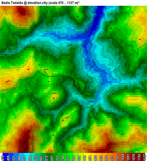
Below is the Elevation map of Badia Tedalda, which displays elevation range with different colors. Scale of the first map is from 470 to 1127 m (1542 to 3698 ft) with average elevation of 738.8 meters (=2424 ft) [note 1]
These maps also provides idea of topography and contour of this city, they are displayed at different zoom levels. More info about maps, scale and edge coordinates you can find below images.
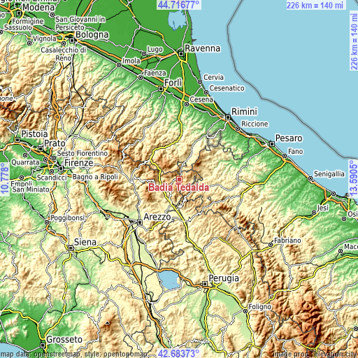
| \ | Map #1 | Topo.Map |
| Scale [m] | 470..1127 m | × |
| Scale [ft] | 1542..3698 ft | × |
| Average | 738.8 m = 2424 ft | × |
| Width | 7.06 km = 4.4 mi | 226.1 km = 140.5 mi |
| Height | 7.06 km = 4.4 mi | 226 km = 140.4 mi |
| ↑Max Latitude | 43.740628° | 44.71677° |
| Latitude at center | 43.70887° | 43.70887° |
| ↓Min Latitude | 43.677095° | 42.68373° |
| ← Min Longitude | 12.140305° | 10.778° |
| Longitude center | 12.18425° | 12.18425° |
| →Max Longitude | 12.228195° | 13.5905° |
Nearby cities:
Cities around Badia Tedalda sort by population:
• Sansepolcro elevation 332 m
15.6 km,  193°
193°
• Pieve Santo Stefano 433 m
12.2 km,  250°
250°
• Carpegna 747 m
14.6 km,  56°
56°
• Mercatello sul Metauro 430 m
14 km,  119°
119°
• Pennabilli 580 m
13.8 km,  28°
28°
• Sant'Agata Feltria 576 m
17.2 km,  6°
6°
• Sestino 506 m
9.1 km,  89°
89°
• Belforte 346 m
15.4 km, 86°
• Casteldelci 582 m
9.4 km,  345°
345°
• Borgo Pace 471 m
10.4 km, 122°
• Verghereto 815 m
17.2 km,  303°
303°
• Frontino 508 m
16.7 km,  68°
68°
Multilingual:
 En español:
Badia Tedalda elevación 699 m.
 En France:
Badia Tedalda élévation 699 m.
 Auf Deutsch:
Badia Tedalda höhe über dem Meeresspiegel ist 699 m.

Sources and notes:
- [note 1] Map square and city borders are not equal. Map elevation data is calculated only from area inside that square.
- [src 1] Elevation data from geonames database provided with same terms of usage.
- [src 2] The elevation map of Badia Tedalda is generated using elevation data from NASA's 3 arcsec (90m) resolution SRTM data.
- [src 3] Base (background) map © OpenStreetMap contributors tiles are generated by Geofabrik and OpenTopoMap.
Copyright & License:
This Badia Tedalda Elevation Map is licensed under CC BY-SA. You may reuse any part from this page, if you give a proper credit by linking to this URL:
 More info on terms of use page.