Sant'Agata Feltria elevation
Sant'Agata Feltria (Emilia-Romagna, Provincia di Rimini), Italy elevation is 576 meters and Sant'Agata Feltria elevation in feet is 1890 ft above sea level [src 1]. Sant'Agata Feltria is a seat of a third-order administrative division (feature code) with elevation that is 254 meters (833 ft) bigger than average city elevation in Italy.
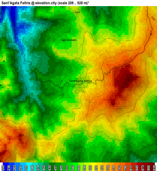
Below is the Elevation map of Sant'Agata Feltria, which displays elevation range with different colors. Scale of the first map is from 208 to 928 m (682 to 3045 ft) with average elevation of 571.5 meters (=1875 ft) [note 1]
These maps also provides idea of topography and contour of this city, they are displayed at different zoom levels. More info about maps, scale and edge coordinates you can find below images.
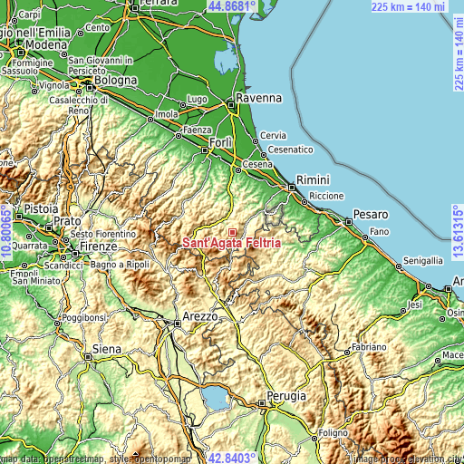
| \ | Map #1 | Topo.Map |
| Scale [m] | 208..928 m | × |
| Scale [ft] | 682..3045 ft | × |
| Average | 571.5 m = 1875 ft | × |
| Width | 7.05 km = 4.4 mi | 225.5 km = 140.1 mi |
| Height | 7.05 km = 4.4 mi | 225.5 km = 140.1 mi |
| ↑Max Latitude | 43.894496° | 44.8681° |
| Latitude at center | 43.86282° | 43.86282° |
| ↓Min Latitude | 43.831127° | 42.8403° |
| ← Min Longitude | 12.162955° | 10.80065° |
| Longitude center | 12.2069° | 12.2069° |
| →Max Longitude | 12.250845° | 13.61315° |
Nearby cities:
Cities around Sant'Agata Feltria sort by population:
• Novafeltria elevation 287 m
7.5 km,  61°
61°
• Mercato Saraceno 177 m
11.1 km,  355°
355°
• Sarsina 256 m
8.2 km,  320°
320°
• Carpegna 747 m
13.7 km,  131°
131°
• Secchiano 217 m
11.1 km,  52°
52°
• Talamello 372 m
7.9 km, 52°
• Pennabilli 580 m
7 km,  136°
136°
• Casteldelci 582 m
9 km,  207°
207°
• Villagrande 913 m
12.5 km,  101°
101°
• Mercato Vecchio 588 m
15.1 km,  115°
115°
• Serra di Maiolo 597 m
8.4 km,  82°
82°
• San Leo 605 m
11.6 km,  71°
71°
Multilingual:
 En español:
Sant'Agata Feltria elevación 576 m.
 En France:
Sant'Agata Feltria élévation 576 m.
 Auf Deutsch:
Sant'Agata Feltria höhe über dem Meeresspiegel ist 576 m.
 На русском:
Sant'Agata Feltria высота над уровнем моря 576 м
Sources and notes:
- [note 1] Map square and city borders are not equal. Map elevation data is calculated only from area inside that square.
- [src 1] Elevation data from geonames database provided with same terms of usage.
- [src 2] The elevation map of Sant'Agata Feltria is generated using elevation data from NASA's 3 arcsec (90m) resolution SRTM data.
- [src 3] Base (background) map © OpenStreetMap contributors tiles are generated by Geofabrik and OpenTopoMap.
Copyright & License:
This Sant'Agata Feltria Elevation Map is licensed under CC BY-SA. You may reuse any part from this page, if you give a proper credit by linking to this URL:
 More info on terms of use page.