Mercatale elevation
Mercatale (The Marches, Provincia di Pesaro e Urbino), Italy elevation is 237 meters and Mercatale elevation in feet is 778 ft above sea level [src 1]. Mercatale is a populated place (feature code) with elevation that is 85 meters (279 ft) smaller than average city elevation in Italy.
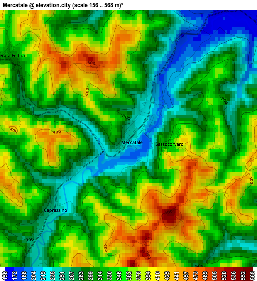
Below is the Elevation map of Mercatale, which displays elevation range with different colors. Scale of the first map is from 156 to 568 m (512 to 1864 ft) with average elevation of 332.4 meters (=1091 ft) [note 1]
These maps also provides idea of topography and contour of this city, they are displayed at different zoom levels. More info about maps, scale and edge coordinates you can find below images.
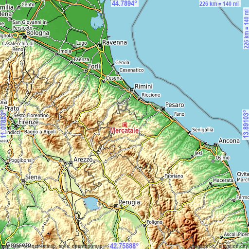
| \ | Map #1 | Topo.Map |
| Scale [m] | 156..568 m | × |
| Scale [ft] | 512..1864 ft | × |
| Average | 332.4 m = 1091 ft | × |
| Width | 7.06 km = 4.4 mi | 225.8 km = 140.3 mi |
| Height | 7.06 km = 4.4 mi | 225.8 km = 140.3 mi |
| ↑Max Latitude | 43.814479° | 44.7894° |
| Latitude at center | 43.78276° | 43.78276° |
| ↓Min Latitude | 43.751024° | 42.75888° |
| ← Min Longitude | 12.440835° | 11.07853° |
| Longitude center | 12.48478° | 12.48478° |
| →Max Longitude | 12.528725° | 13.89103° |
Nearby cities:
Cities around Mercatale sort by population:
• Piandimeleto elevation 325 m
9 km,  222°
222°
• Macerata Feltria 312 m
4.1 km,  303°
303°
• Lunano 276 m
6.5 km,  210°
210°
• Casinina 188 m
8.8 km,  64°
64°
• Sassocorvaro 342 m
1.1 km,  90°
90°
• Mercatino Conca 284 m
9.7 km,  3°
3°
• Peglio 473 m
9.7 km,  173°
173°
• Monte Grimano Terme 511 m
9.5 km,  353°
353°
• Monte Cerignone 505 m
8.5 km,  318°
318°
• Mercato Vecchio 588 m
9 km,  285°
285°
• Auditore 359 m
8.2 km, 58°
• Frontino 508 m
8.9 km,  256°
256°
Multilingual:
 En español:
Mercatale elevación 237 m.
 En France:
Mercatale élévation 237 m.
 Auf Deutsch:
Mercatale höhe über dem Meeresspiegel ist 237 m.

Sources and notes:
- [note 1] Map square and city borders are not equal. Map elevation data is calculated only from area inside that square.
- [src 1] Elevation data from geonames database provided with same terms of usage.
- [src 2] The elevation map of Mercatale is generated using elevation data from NASA's 3 arcsec (90m) resolution SRTM data.
- [src 3] Base (background) map © OpenStreetMap contributors tiles are generated by Geofabrik and OpenTopoMap.
Copyright & License:
This Mercatale Elevation Map is licensed under CC BY-SA. You may reuse any part from this page, if you give a proper credit by linking to this URL:
 More info on terms of use page.