Jamjamāl elevation
Jamjamāl (Sulaymaniyah, Chamchamal District), Iraq elevation is 705 meters and Jamjamāl elevation in feet is 2313 ft above sea level [src 1]. Jamjamāl is a seat of a second-order administrative division (feature code) with elevation that is 412 meters (1352 ft) bigger than average city elevation in Iraq.
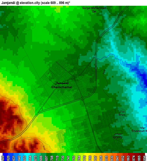
Below is the Elevation map of Jamjamāl, which displays elevation range with different colors. Scale of the first map is from 609 to 896 m (1998 to 2940 ft) with average elevation of 724 meters (=2375 ft) [note 1]
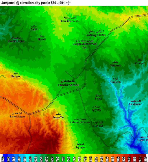
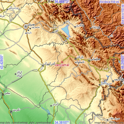
These maps also provides idea of topography and contour of this city, they are displayed at different zoom levels. More info about maps, scale and edge coordinates you can find below images.
| \ | Map #1 | Map #2 | Topo.Map |
| Scale [m] | 609..896 m | 530..991 m | × |
| Scale [ft] | 1998..2940 ft | 1739..3251 ft | × |
| Average | 724 m = 2375 ft | 743.3 m = 2439 ft | × |
| Width | 7.95 km = 4.9 mi | 15.91 km = 9.9 mi | 254.5 km = 158.1 mi |
| Height | 7.95 km = 4.9 mi | 15.91 km = 9.9 mi | 254.5 km = 158.1 mi |
| ↑Max Latitude | 35.569314° | 35.605051° | 36.66973° |
| Latitude at center | 35.53356° | 35.53356° | 35.53356° |
| ↓Min Latitude | 35.49779° | 35.462005° | 34.38107° |
| ← Min Longitude | 44.790355° | 44.746409° | 43.42805° |
| Longitude center | 44.8343° | 44.8343° | 44.8343° |
| →Max Longitude | 44.878245° | 44.922191° | 46.24055° |
Nearby cities:
Cities around Jamjamāl sort by population:
• As Sulaymānīyah elevation 847 m
54.3 km,  86°
86°
• Kirkuk 346 m
40.7 km,  259°
259°
• Tozkhurmato 227 m
74.1 km,  194°
194°
• Koysinceq 600 m
63.8 km,  343°
343°
• Hayraw 1264 m
77.4 km,  31°
31°
• Qeładizê 601 m
76.9 km,  20°
20°
• Dibis 242 m
70.8 km,  282°
282°
• Chwarta 1316 m
69.8 km,  72°
72°
• Mawet 892 m
66.4 km,  52°
52°
• Qeredagh 879 m
56.3 km,  116°
116°
• Dāqūq 227 m
56.1 km,  218°
218°
• Dukan 423 m
45.5 km,  14°
14°
Multilingual:
 En español:
Jamjamāl elevación 705 m.
 En France:
Jamjamāl élévation 705 m.
 Auf Deutsch:
Jamjamāl höhe über dem Meeresspiegel ist 705 m.

Sources and notes:
- [note 1] Map square and city borders are not equal. Map elevation data is calculated only from area inside that square.
- [src 1] Elevation data from geonames database provided with same terms of usage.
- [src 2] The elevation map of Jamjamāl is generated using elevation data from NASA's 3 arcsec (90m) resolution SRTM data.
- [src 3] Base (background) map © OpenStreetMap contributors tiles are generated by Geofabrik and OpenTopoMap.
Copyright & License:
This Jamjamāl Elevation Map is licensed under CC BY-SA. You may reuse any part from this page, if you give a proper credit by linking to this URL:
 More info on terms of use page.