Chwarta elevation
Chwarta (Sulaymaniyah, Sharbazher District), Iraq elevation is 1316 meters and Chwarta elevation in feet is 4318 ft above sea level [src 1]. Chwarta is a seat of a second-order administrative division (feature code) with elevation that is 1023 meters (3356 ft) bigger than average city elevation in Iraq.
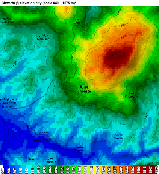
Below is the Elevation map of Chwarta, which displays elevation range with different colors. Scale of the first map is from 840 to 1575 m (2756 to 5167 ft) with average elevation of 1072.7 meters (=3519 ft) [note 1]
These maps also provides idea of topography and contour of this city, they are displayed at different zoom levels. More info about maps, scale and edge coordinates you can find below images.
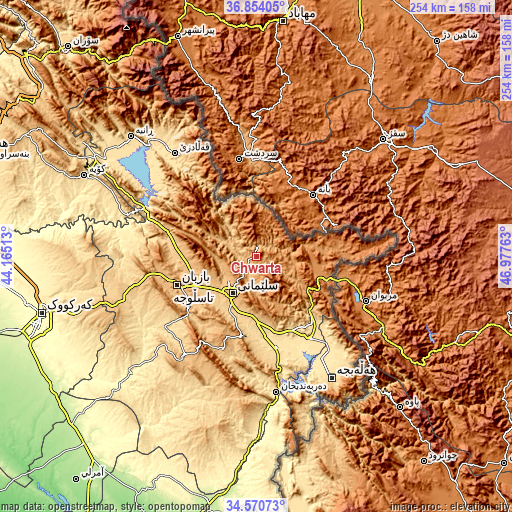
| \ | Map #1 | Topo.Map |
| Scale [m] | 840..1575 m | × |
| Scale [ft] | 2756..5167 ft | × |
| Average | 1072.7 m = 3519 ft | × |
| Width | 7.93 km = 4.9 mi | 253.9 km = 157.8 mi |
| Height | 7.93 km = 4.9 mi | 253.9 km = 157.8 mi |
| ↑Max Latitude | 35.75624° | 36.85405° |
| Latitude at center | 35.72057° | 35.72057° |
| ↓Min Latitude | 35.684884° | 34.57073° |
| ← Min Longitude | 45.527435° | 44.16513° |
| Longitude center | 45.57138° | 45.57138° |
| →Max Longitude | 45.615325° | 46.97763° |
Nearby cities:
Cities around Chwarta sort by population:
• As Sulaymānīyah elevation 847 m
21.4 km,  215°
215°
• Jamjamāl 705 m
69.8 km,  252°
252°
• Baynjiwayn 1256 m
35.9 km,  108°
108°
• Derbendîxan 510 m
68.5 km,  171°
171°
• Qeładizê 601 m
64.9 km,  322°
322°
• Halshaw 1064 m
61.1 km,  332°
332°
• Dukan 423 m
59.6 km,  292°
292°
• Hayraw 1264 m
52.1 km, 330°
• Seyid Sadiq 509 m
48.9 km,  146°
146°
• Qeredagh 879 m
48.8 km,  199°
199°
• Ḩalabjah al Jadīdah 538 m
45.8 km, 166°
• Mawet 892 m
24.6 km, 324°
Multilingual:
 En español:
Chwarta elevación 1316 m.
 En France:
Chwarta élévation 1316 m.
 Auf Deutsch:
Chwarta höhe über dem Meeresspiegel ist 1316 m.

Sources and notes:
- [note 1] Map square and city borders are not equal. Map elevation data is calculated only from area inside that square.
- [src 1] Elevation data from geonames database provided with same terms of usage.
- [src 2] The elevation map of Chwarta is generated using elevation data from NASA's 3 arcsec (90m) resolution SRTM data.
- [src 3] Base (background) map © OpenStreetMap contributors tiles are generated by Geofabrik and OpenTopoMap.
Copyright & License:
This Chwarta Elevation Map is licensed under CC BY-SA. You may reuse any part from this page, if you give a proper credit by linking to this URL:
 More info on terms of use page.