Hayraw elevation
Hayraw (Sulaymaniyah, Pshdar District), Iraq elevation is 1264 meters and Hayraw elevation in feet is 4147 ft above sea level [src 1]. Hayraw is a seat of a third-order administrative division (feature code) with elevation that is 971 meters (3186 ft) bigger than average city elevation in Iraq.
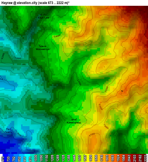
Below is the Elevation map of Hayraw, which displays elevation range with different colors. Scale of the first map is from 673 to 2222 m (2208 to 7290 ft) with average elevation of 1382.4 meters (=4535 ft) [note 1]
These maps also provides idea of topography and contour of this city, they are displayed at different zoom levels. More info about maps, scale and edge coordinates you can find below images.
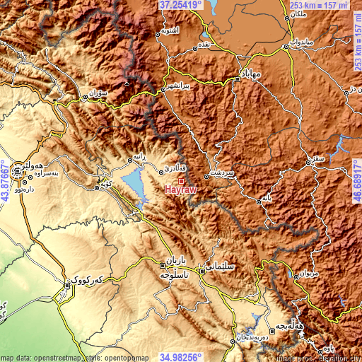
| \ | Map #1 | Topo.Map |
| Scale [m] | 673..2222 m | × |
| Scale [ft] | 2208..7290 ft | × |
| Average | 1382.4 m = 4535 ft | × |
| Width | 7.89 km = 4.9 mi | 252.6 km = 157 mi |
| Height | 7.89 km = 4.9 mi | 252.6 km = 157 mi |
| ↑Max Latitude | 36.162077° | 37.25419° |
| Latitude at center | 36.12659° | 36.12659° |
| ↓Min Latitude | 36.091087° | 34.98256° |
| ← Min Longitude | 45.238975° | 43.87667° |
| Longitude center | 45.28292° | 45.28292° |
| →Max Longitude | 45.326865° | 46.68917° |
Nearby cities:
Cities around Hayraw sort by population:
• As Sulaymānīyah elevation 847 m
63.9 km,  167°
167°
• Jamjamāl 705 m
77.4 km,  211°
211°
• Koysinceq 600 m
59 km,  265°
265°
• Nāḩiyat Hīrān 1036 m
73.3 km,  283°
283°
• Hīrān 906 m
72.8 km, 283°
• Choman 1111 m
66.8 km,  328°
328°
• Chwarta 1316 m
52.1 km,  150°
150°
• Ṟaniye 574 m
38.7 km,  291°
291°
• Dukan 423 m
36.2 km,  232°
232°
• Mawet 892 m
27.7 km, 154°
• Qeładizê 601 m
15.1 km, 294°
• Halshaw 1064 m
9.4 km,  346°
346°
Multilingual:
 En español:
Hayraw elevación 1264 m.
 En France:
Hayraw élévation 1264 m.


Sources and notes:
- [note 1] Map square and city borders are not equal. Map elevation data is calculated only from area inside that square.
- [src 1] Elevation data from geonames database provided with same terms of usage.
- [src 2] The elevation map of Hayraw is generated using elevation data from NASA's 3 arcsec (90m) resolution SRTM data.
- [src 3] Base (background) map © OpenStreetMap contributors tiles are generated by Geofabrik and OpenTopoMap.
Copyright & License:
This Hayraw Elevation Map is licensed under CC BY-SA. You may reuse any part from this page, if you give a proper credit by linking to this URL:
 More info on terms of use page.