Tozkhurmato elevation
Tozkhurmato (Salah ad Din, Tooz District), Iraq elevation is 227 meters and Tozkhurmato elevation in feet is 745 ft above sea level [src 1]. Tozkhurmato is a seat of a second-order administrative division (feature code) with elevation that is 66 meters (217 ft) smaller than average city elevation in Iraq.
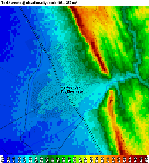
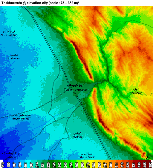
Below is the Elevation map of Tozkhurmato, which displays elevation range with different colors. Scale of the first map is from 198 to 352 m (650 to 1155 ft) with average elevation of 237.9 meters (=781 ft) [note 1]
These maps also provides idea of topography and contour of this city, they are displayed at different zoom levels. More info about maps, scale and edge coordinates you can find below images.
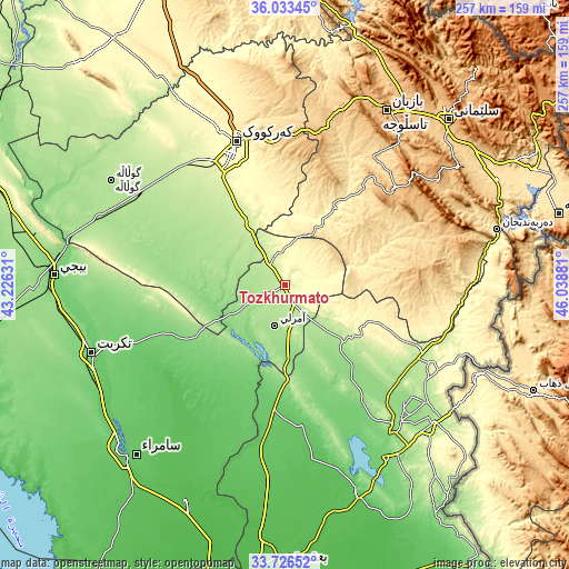
| \ | Map #1 | Map #2 | Topo.Map |
| Scale [m] | 198..352 m | 173..352 m | × |
| Scale [ft] | 650..1155 ft | 568..1155 ft | × |
| Average | 237.9 m = 781 ft | 239.1 m = 784 ft | × |
| Width | 8.02 km = 5 mi | 16.03 km = 10 mi | 256.5 km = 159.4 mi |
| Height | 8.02 km = 5 mi | 16.03 km = 10 mi | 256.5 km = 159.4 mi |
| ↑Max Latitude | 34.924119° | 34.960142° | 36.03345° |
| Latitude at center | 34.88808° | 34.88808° | 34.88808° |
| ↓Min Latitude | 34.852025° | 34.815954° | 33.72652° |
| ← Min Longitude | 44.588615° | 44.544669° | 43.22631° |
| Longitude center | 44.63256° | 44.63256° | 44.63256° |
| →Max Longitude | 44.676505° | 44.720451° | 46.03881° |
Nearby cities:
Cities around Tozkhurmato sort by population:
• Kirkuk elevation 346 m
68.1 km,  341°
341°
• Jamjamāl 705 m
74.1 km,  14°
14°
• Tikrīt 112 m
92.3 km,  250°
250°
• Kifrī 229 m
37.2 km,  126°
126°
• Al Ḩawījah 192 m
92.1 km,  301°
301°
• Khānaqīn 185 m
91.7 km, 130°
• Al ‘Awjah 77 m
91.2 km,  244°
244°
• Ad Dawr 93 m
90.5 km, 237°
• Qeredagh 879 m
83.2 km,  55°
55°
• Ar Riyāḑ 189 m
78.2 km, 302°
• Kelar 216 m
69 km,  114°
114°
• Dāqūq 227 m
32.5 km,  329°
329°
Multilingual:
 En español:
Tozkhurmato elevación 227 m.
 En France:
Tozkhurmato élévation 227 m.
 Auf Deutsch:
Tozkhurmato höhe über dem Meeresspiegel ist 227 m.

Sources and notes:
- [note 1] Map square and city borders are not equal. Map elevation data is calculated only from area inside that square.
- [src 1] Elevation data from geonames database provided with same terms of usage.
- [src 2] The elevation map of Tozkhurmato is generated using elevation data from NASA's 3 arcsec (90m) resolution SRTM data.
- [src 3] Base (background) map © OpenStreetMap contributors tiles are generated by Geofabrik and OpenTopoMap.
Copyright & License:
This Tozkhurmato Elevation Map is licensed under CC BY-SA. You may reuse any part from this page, if you give a proper credit by linking to this URL:
 More info on terms of use page.