Kirkuk elevation
Kirkuk, Iraq elevation is 346 meters and Kirkuk elevation in feet is 1135 ft above sea level [src 1]. Kirkuk is a seat of a first-order administrative division (feature code) with elevation that is 53 meters (174 ft) bigger than average city elevation in Iraq.
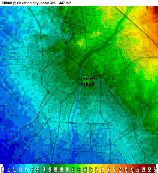
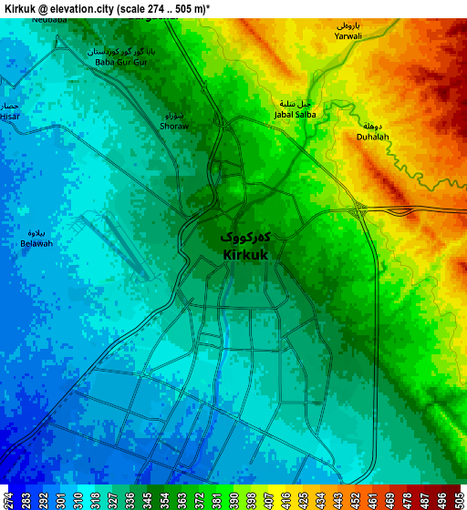
Below is the Elevation map of Kirkuk, which displays elevation range with different colors. Scale of the first map is from 306 to 447 m (1004 to 1467 ft) with average elevation of 344.4 meters (=1130 ft) [note 1]
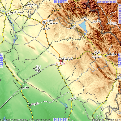
These maps also provides idea of topography and contour of this city, they are displayed at different zoom levels. More info about maps, scale and edge coordinates you can find below images.
| \ | Map #1 | Map #2 | Topo.Map |
| Scale [m] | 306..447 m | 274..505 m | × |
| Scale [ft] | 1004..1467 ft | 899..1657 ft | × |
| Average | 344.4 m = 1130 ft | 350.2 m = 1149 ft | × |
| Width | 7.96 km = 4.9 mi | 15.92 km = 9.9 mi | 254.7 km = 158.3 mi |
| Height | 7.96 km = 4.9 mi | 15.92 km = 9.9 mi | 254.7 km = 158.3 mi |
| ↑Max Latitude | 35.503843° | 35.53961° | 36.60517° |
| Latitude at center | 35.46806° | 35.46806° | 35.46806° |
| ↓Min Latitude | 35.432261° | 35.396447° | 34.31464° |
| ← Min Longitude | 44.348275° | 44.304329° | 42.98597° |
| Longitude center | 44.39222° | 44.39222° | 44.39222° |
| →Max Longitude | 44.436165° | 44.480111° | 45.79847° |
Nearby cities:
Cities around Kirkuk sort by population:
• Jamjamāl elevation 705 m
40.7 km,  79°
79°
• Tozkhurmato 227 m
68.1 km,  161°
161°
• Koysinceq 600 m
71.6 km,  17°
17°
• Mexmur 266 m
81 km,  295°
295°
• Dare Tû 439 m
78.5 km,  337°
337°
• Al ‘Abbāsī 174 m
75.3 km,  253°
253°
• Dukan 423 m
72.7 km,  45°
45°
• Qushtepe 396 m
67.4 km,  331°
331°
• Al Ḩawījah 192 m
58.3 km, 254°
• Ar Riyāḑ 189 m
48.9 km,  243°
243°
• Dibis 242 m
37.1 km,  308°
308°
• Dāqūq 227 m
36.9 km,  171°
171°
Multilingual:
 En español:
Kirkuk elevación 346 m.
 En France:
Kirkouk élévation 346 m.


Sources and notes:
- [note 1] Map square and city borders are not equal. Map elevation data is calculated only from area inside that square.
- [src 1] Elevation data from geonames database provided with same terms of usage.
- [src 2] The elevation map of Kirkuk is generated using elevation data from NASA's 3 arcsec (90m) resolution SRTM data.
- [src 3] Base (background) map © OpenStreetMap contributors tiles are generated by Geofabrik and OpenTopoMap.
Copyright & License:
This Kirkuk Elevation Map is licensed under CC BY-SA. You may reuse any part from this page, if you give a proper credit by linking to this URL:
 More info on terms of use page.