Ambikāpur elevation
Ambikāpur (Chhattisgarh, Surguja), India elevation is 603 meters and Ambikāpur elevation in feet is 1978 ft above sea level [src 1]. Ambikāpur is a seat of a second-order administrative division (feature code) with elevation that is 310 meters (1017 ft) bigger than average city elevation in India.
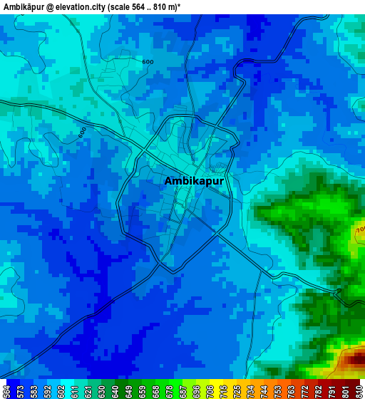
Below is the Elevation map of Ambikāpur, which displays elevation range with different colors. Scale of the first map is from 564 to 810 m (1850 to 2657 ft) with average elevation of 599.3 meters (=1966 ft) [note 1]
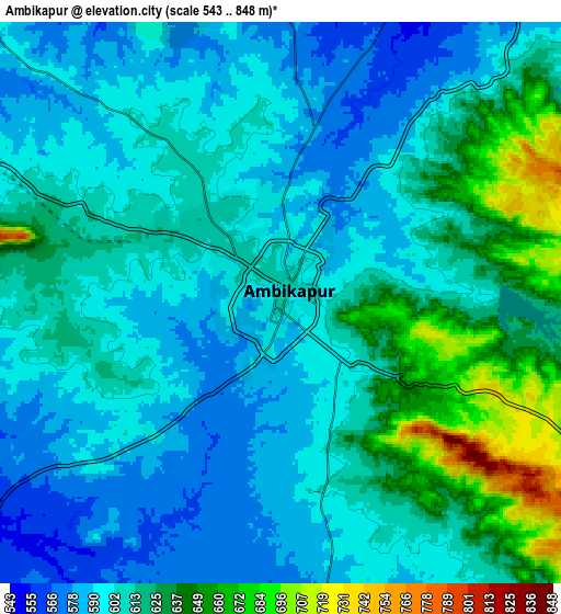
These maps also provides idea of topography and contour of this city, they are displayed at different zoom levels. More info about maps, scale and edge coordinates you can find below images.
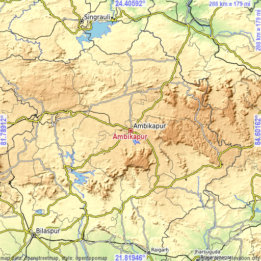
| \ | Map #1 | Map #2 | Topo.Map |
| Scale [m] | 564..810 m | 543..848 m | × |
| Scale [ft] | 1850..2657 ft | 1781..2782 ft | × |
| Average | 599.3 m = 1966 ft | 609.9 m = 2001 ft | × |
| Width | 8.99 km = 5.6 mi | 17.98 km = 11.2 mi | 287.6 km = 178.7 mi |
| Height | 8.99 km = 5.6 mi | 17.98 km = 11.2 mi | 287.6 km = 178.7 mi |
| ↑Max Latitude | 23.15933° | 23.199728° | 24.40592° |
| Latitude at center | 23.11892° | 23.11892° | 23.11892° |
| ↓Min Latitude | 23.078498° | 23.038063° | 21.81946° |
| ← Min Longitude | 83.151425° | 83.107479° | 81.78912° |
| Longitude center | 83.19537° | 83.19537° | 83.19537° |
| →Max Longitude | 83.239315° | 83.283261° | 84.60162° |
Nearby cities:
Cities around Ambikāpur sort by population:
• Korba elevation 289 m
100 km,  210°
210°
• Pasān 536 m
106.5 km,  253°
253°
• Jashpurnagar 776 m
99.9 km,  104°
104°
• Katghora 325 m
95.8 km,  224°
224°
• Pathalgaon 573 m
68.3 km,  156°
156°
• Dūdhi 250 m
121.8 km,  2°
2°
• Baikunthpur 560 m
66.8 km,  283°
283°
• Rāmānuj Ganj 436 m
92.1 km,  33°
33°
• Gharghoda 294 m
106.3 km,  171°
171°
• Neturhāt 1086 m
116.4 km,  70°
70°
• Balrampur 532 m
69.3 km,  37°
37°
• Surajpur 557 m
35 km,  287°
287°
Multilingual:
 En español:
Ambikāpur elevación 603 m.
 En France:
Ambikāpur élévation 603 m.
 Auf Deutsch:
Ambikāpur höhe über dem Meeresspiegel ist 603 m.

Sources and notes:
- [note 1] Map square and city borders are not equal. Map elevation data is calculated only from area inside that square.
- [src 1] Elevation data from geonames database provided with same terms of usage.
- [src 2] The elevation map of Ambikāpur is generated using elevation data from NASA's 3 arcsec (90m) resolution SRTM data.
- [src 3] Base (background) map © OpenStreetMap contributors tiles are generated by Geofabrik and OpenTopoMap.
Copyright & License:
This Ambikāpur Elevation Map is licensed under CC BY-SA. You may reuse any part from this page, if you give a proper credit by linking to this URL:
 More info on terms of use page.