Pasān elevation
Pasān (Chhattisgarh, Korba), India elevation is 536 meters and Pasān elevation in feet is 1759 ft above sea level [src 1]. Pasān is a populated place (feature code) with elevation that is 243 meters (797 ft) bigger than average city elevation in India.
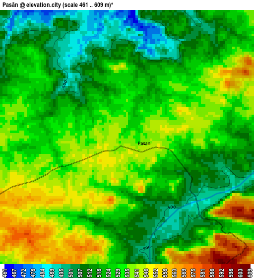
Below is the Elevation map of Pasān, which displays elevation range with different colors. Scale of the first map is from 461 to 609 m (1512 to 1998 ft) with average elevation of 526.5 meters (=1727 ft) [note 1]
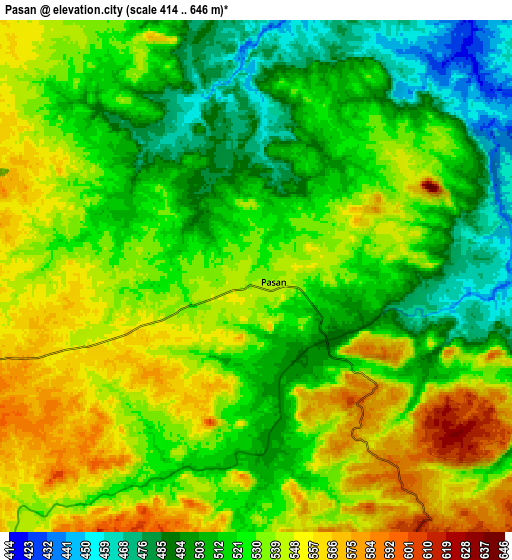
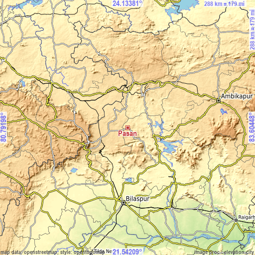
These maps also provides idea of topography and contour of this city, they are displayed at different zoom levels. More info about maps, scale and edge coordinates you can find below images.
| \ | Map #1 | Map #2 | Topo.Map |
| Scale [m] | 461..609 m | 414..646 m | × |
| Scale [ft] | 1512..1998 ft | 1358..2119 ft | × |
| Average | 526.5 m = 1727 ft | 526.2 m = 1726 ft | × |
| Width | 9.01 km = 5.6 mi | 18.01 km = 11.2 mi | 288.2 km = 179.1 mi |
| Height | 9.01 km = 5.6 mi | 18.01 km = 11.2 mi | 288.2 km = 179.1 mi |
| ↑Max Latitude | 22.884612° | 22.925093° | 24.13381° |
| Latitude at center | 22.84412° | 22.84412° | 22.84412° |
| ↓Min Latitude | 22.803616° | 22.763099° | 21.54209° |
| ← Min Longitude | 82.154285° | 82.110339° | 80.79198° |
| Longitude center | 82.19823° | 82.19823° | 82.19823° |
| →Max Longitude | 82.242175° | 82.286121° | 83.60448° |
Nearby cities:
Cities around Pasān sort by population:
• Korba elevation 289 m
75.4 km,  137°
137°
• Kotma 535 m
45.9 km,  330°
330°
• Ratanpur 304 m
62.1 km,  182°
182°
• Katghora 325 m
51.9 km, 137°
• Burhar 486 m
79.7 km,  301°
301°
• Anūppur 503 m
59.4 km, 299°
• Kotā 333 m
63.6 km,  196°
196°
• Gaurela 622 m
32 km,  251°
251°
• Pendra 613 m
25.6 km, 252°
• Baikunthpur 560 m
59.4 km,  38°
38°
• Amarkantak 1042 m
48.8 km, 247°
• Surajpur 557 m
79.9 km,  59°
59°
Multilingual:
 En español:
Pasān elevación 536 m.
 En France:
Pasān élévation 536 m.


Sources and notes:
- [note 1] Map square and city borders are not equal. Map elevation data is calculated only from area inside that square.
- [src 1] Elevation data from geonames database provided with same terms of usage.
- [src 2] The elevation map of Pasān is generated using elevation data from NASA's 3 arcsec (90m) resolution SRTM data.
- [src 3] Base (background) map © OpenStreetMap contributors tiles are generated by Geofabrik and OpenTopoMap.
Copyright & License:
This Pasān Elevation Map is licensed under CC BY-SA. You may reuse any part from this page, if you give a proper credit by linking to this URL:
 More info on terms of use page.