Baikunthpur elevation
Baikunthpur (Chhattisgarh, Koriya), India elevation is 560 meters and Baikunthpur elevation in feet is 1837 ft above sea level [src 1]. Baikunthpur is a populated place (feature code) with elevation that is 267 meters (876 ft) bigger than average city elevation in India.
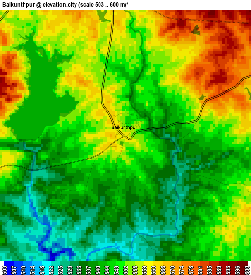
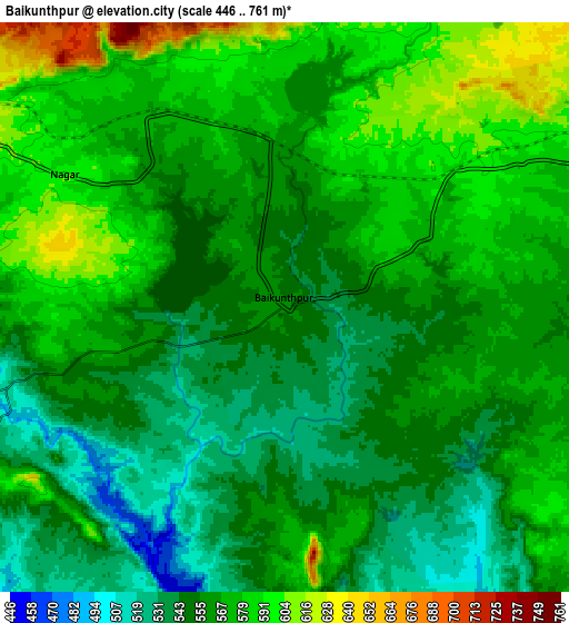
Below is the Elevation map of Baikunthpur, which displays elevation range with different colors. Scale of the first map is from 503 to 600 m (1650 to 1969 ft) with average elevation of 549.1 meters (=1802 ft) [note 1]
These maps also provides idea of topography and contour of this city, they are displayed at different zoom levels. More info about maps, scale and edge coordinates you can find below images.
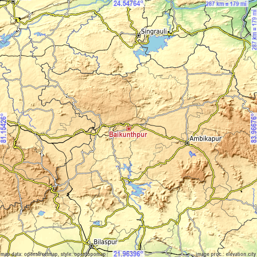
| \ | Map #1 | Map #2 | Topo.Map |
| Scale [m] | 503..600 m | 446..761 m | × |
| Scale [ft] | 1650..1969 ft | 1463..2497 ft | × |
| Average | 549.1 m = 1802 ft | 564.1 m = 1851 ft | × |
| Width | 8.98 km = 5.6 mi | 17.96 km = 11.2 mi | 287.3 km = 178.5 mi |
| Height | 8.98 km = 5.6 mi | 17.96 km = 11.2 mi | 287.3 km = 178.5 mi |
| ↑Max Latitude | 23.302427° | 23.342781° | 24.54764° |
| Latitude at center | 23.26206° | 23.26206° | 23.26206° |
| ↓Min Latitude | 23.221681° | 23.18129° | 21.96396° |
| ← Min Longitude | 82.516565° | 82.472619° | 81.15426° |
| Longitude center | 82.56051° | 82.56051° | 82.56051° |
| →Max Longitude | 82.604455° | 82.648401° | 83.96676° |
Nearby cities:
Cities around Baikunthpur sort by population:
• Korba elevation 289 m
102.8 km,  172°
172°
• Singrauli 383 m
104.9 km,  6°
6°
• Ambikāpur 603 m
66.8 km,  103°
103°
• Kotma 535 m
59.8 km,  263°
263°
• Pasān 536 m
59.4 km,  218°
218°
• Katghora 325 m
84.5 km,  181°
181°
• Burhar 486 m
105.2 km,  267°
267°
• Anūppur 503 m
90.6 km, 258°
• Gaurela 622 m
88 km,  230°
230°
• Pendra 613 m
81.9 km, 228°
• Amarkantak 1042 m
104.9 km, 231°
• Surajpur 557 m
31.9 km, 99°
Multilingual:
 En español:
Baikunthpur elevación 560 m.
 En France:
Baikunthpur élévation 560 m.
 Auf Deutsch:
Baikunthpur höhe über dem Meeresspiegel ist 560 m.

Sources and notes:
- [note 1] Map square and city borders are not equal. Map elevation data is calculated only from area inside that square.
- [src 1] Elevation data from geonames database provided with same terms of usage.
- [src 2] The elevation map of Baikunthpur is generated using elevation data from NASA's 3 arcsec (90m) resolution SRTM data.
- [src 3] Base (background) map © OpenStreetMap contributors tiles are generated by Geofabrik and OpenTopoMap.
Copyright & License:
This Baikunthpur Elevation Map is licensed under CC BY-SA. You may reuse any part from this page, if you give a proper credit by linking to this URL:
 More info on terms of use page.