Pathalgaon elevation
Pathalgaon (Chhattisgarh, Jashpur), India elevation is 573 meters and Pathalgaon elevation in feet is 1880 ft above sea level [src 1]. Pathalgaon is a populated place (feature code) with elevation that is 280 meters (919 ft) bigger than average city elevation in India.
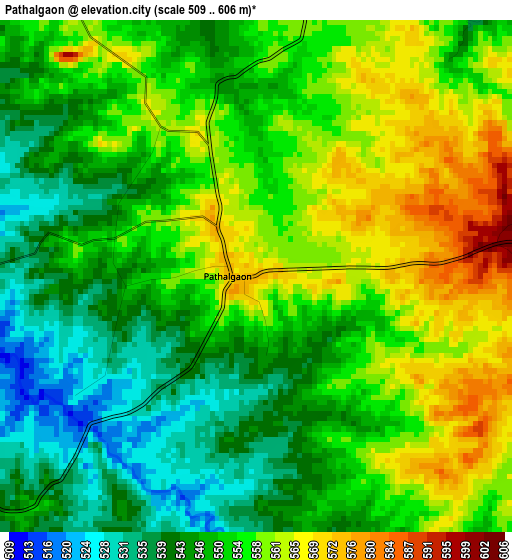
Below is the Elevation map of Pathalgaon, which displays elevation range with different colors. Scale of the first map is from 509 to 606 m (1670 to 1988 ft) with average elevation of 551.9 meters (=1811 ft) [note 1]
These maps also provides idea of topography and contour of this city, they are displayed at different zoom levels. More info about maps, scale and edge coordinates you can find below images.
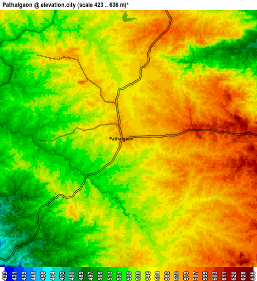
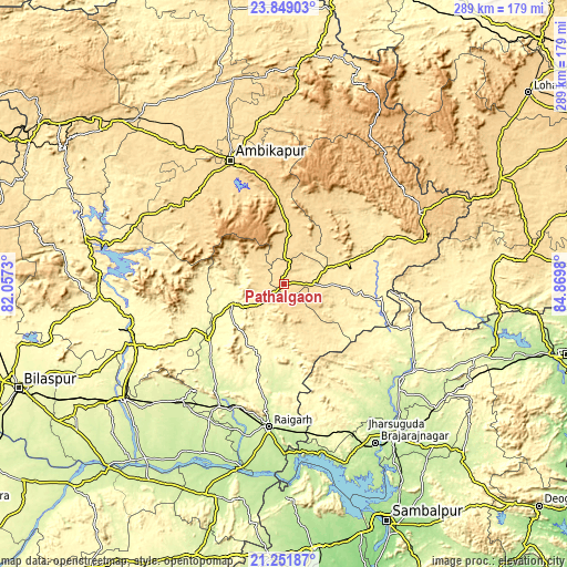
| \ | Map #1 | Map #2 | Topo.Map |
| Scale [m] | 509..606 m | 423..636 m | × |
| Scale [ft] | 1670..1988 ft | 1388..2087 ft | × |
| Average | 551.9 m = 1811 ft | 547.1 m = 1795 ft | × |
| Width | 9.02 km = 5.6 mi | 18.05 km = 11.2 mi | 288.8 km = 179.5 mi |
| Height | 9.03 km = 5.6 mi | 18.05 km = 11.2 mi | 288.8 km = 179.5 mi |
| ↑Max Latitude | 22.597138° | 22.637703° | 23.84903° |
| Latitude at center | 22.55656° | 22.55656° | 22.55656° |
| ↓Min Latitude | 22.51597° | 22.475369° | 21.25187° |
| ← Min Longitude | 83.419605° | 83.375659° | 82.0573° |
| Longitude center | 83.46355° | 83.46355° | 83.46355° |
| →Max Longitude | 83.507495° | 83.551441° | 84.8698° |
Nearby cities:
Cities around Pathalgaon sort by population:
• Korba elevation 289 m
82.2 km,  253°
253°
• Raigarh 224 m
73.6 km,  185°
185°
• Jharsuguda 219 m
96 km,  144°
144°
• Brājarājnagar 219 m
94.6 km,  150°
150°
• Ambikāpur 603 m
68.3 km,  336°
336°
• Sundargarh 239 m
76.3 km,  129°
129°
• Jashpurnagar 776 m
78.4 km,  61°
61°
• Saktī 245 m
78.4 km,  221°
221°
• Katghora 325 m
94.8 km,  266°
266°
• Kharsia 262 m
73.1 km,  210°
210°
• Gharghoda 294 m
44 km,  195°
195°
• Surajpur 557 m
95.1 km,  320°
320°
Multilingual:
 En español:
Pathalgaon elevación 573 m.
 En France:
Pathalgaon élévation 573 m.
 Auf Deutsch:
Pathalgaon höhe über dem Meeresspiegel ist 573 m.

Sources and notes:
- [note 1] Map square and city borders are not equal. Map elevation data is calculated only from area inside that square.
- [src 1] Elevation data from geonames database provided with same terms of usage.
- [src 2] The elevation map of Pathalgaon is generated using elevation data from NASA's 3 arcsec (90m) resolution SRTM data.
- [src 3] Base (background) map © OpenStreetMap contributors tiles are generated by Geofabrik and OpenTopoMap.
Copyright & License:
This Pathalgaon Elevation Map is licensed under CC BY-SA. You may reuse any part from this page, if you give a proper credit by linking to this URL:
 More info on terms of use page.