Jashpurnagar elevation
Jashpurnagar (Chhattisgarh, Jashpur), India elevation is 776 meters and Jashpurnagar elevation in feet is 2546 ft above sea level [src 1]. Jashpurnagar is a populated place (feature code) with elevation that is 483 meters (1585 ft) bigger than average city elevation in India.
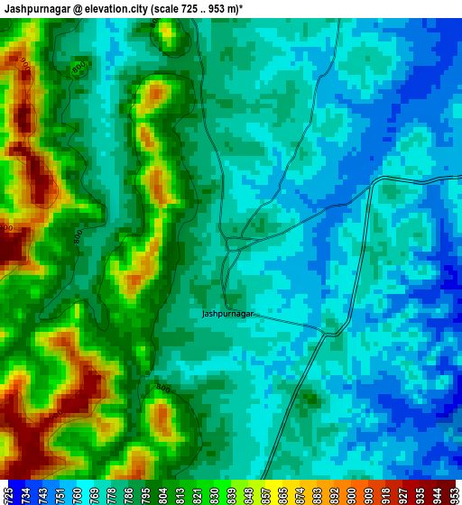
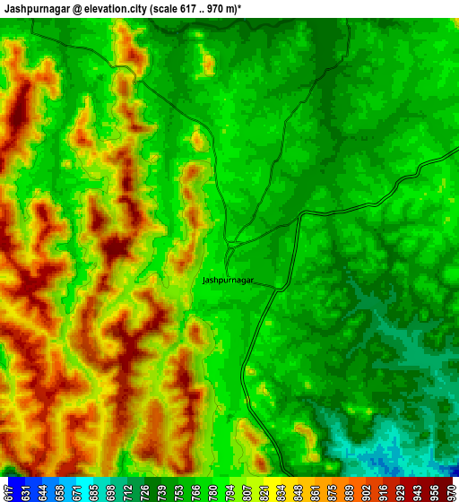
Below is the Elevation map of Jashpurnagar, which displays elevation range with different colors. Scale of the first map is from 725 to 953 m (2379 to 3127 ft) with average elevation of 791.5 meters (=2597 ft) [note 1]
These maps also provides idea of topography and contour of this city, they are displayed at different zoom levels. More info about maps, scale and edge coordinates you can find below images.
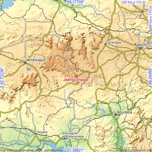
| \ | Map #1 | Map #2 | Topo.Map |
| Scale [m] | 725..953 m | 617..970 m | × |
| Scale [ft] | 2379..3127 ft | 2024..3182 ft | × |
| Average | 791.5 m = 2597 ft | 791.3 m = 2596 ft | × |
| Width | 9 km = 5.6 mi | 18.01 km = 11.2 mi | 288.1 km = 179 mi |
| Height | 9 km = 5.6 mi | 18.01 km = 11.2 mi | 288.1 km = 179 mi |
| ↑Max Latitude | 22.928309° | 22.968777° | 24.17709° |
| Latitude at center | 22.88783° | 22.88783° | 22.88783° |
| ↓Min Latitude | 22.847339° | 22.806835° | 21.58621° |
| ← Min Longitude | 84.094695° | 84.050749° | 82.73239° |
| Longitude center | 84.13864° | 84.13864° | 84.13864° |
| →Max Longitude | 84.182585° | 84.226531° | 85.54489° |
Nearby cities:
Cities around Jashpurnagar sort by population:
• Raurkela elevation 195 m
104.8 km,  134°
134°
• Ambikāpur 603 m
99.9 km,  284°
284°
• Lohārdagā 666 m
82.1 km,  42°
42°
• Gumlā 650 m
45 km,  67°
67°
• Sundargarh 239 m
86.4 km,  187°
187°
• Simdega 443 m
48 km, 129°
• Birmitrapur 257 m
84.2 km, 130°
• Lātehār 388 m
102.1 km,  21°
21°
• Pathalgaon 573 m
78.4 km,  241°
241°
• Bānposh 199 m
99.1 km,  135°
135°
• Neturhāt 1086 m
66.6 km,  11°
11°
• Balrampur 532 m
96.9 km,  326°
326°
Multilingual:
 En español:
Jashpurnagar elevación 776 m.
 En France:
Jashpurnagar élévation 776 m.
 Auf Deutsch:
Jashpurnagar höhe über dem Meeresspiegel ist 776 m.

Sources and notes:
- [note 1] Map square and city borders are not equal. Map elevation data is calculated only from area inside that square.
- [src 1] Elevation data from geonames database provided with same terms of usage.
- [src 2] The elevation map of Jashpurnagar is generated using elevation data from NASA's 3 arcsec (90m) resolution SRTM data.
- [src 3] Base (background) map © OpenStreetMap contributors tiles are generated by Geofabrik and OpenTopoMap.
Copyright & License:
This Jashpurnagar Elevation Map is licensed under CC BY-SA. You may reuse any part from this page, if you give a proper credit by linking to this URL:
 More info on terms of use page.