Bāsār elevation
Bāsār (Arunachal Pradesh, West Siang), India elevation is 620 meters and Bāsār elevation in feet is 2034 ft above sea level [src 1]. Bāsār is a populated place (feature code) with elevation that is 327 meters (1073 ft) bigger than average city elevation in India.
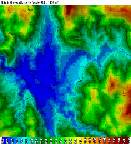
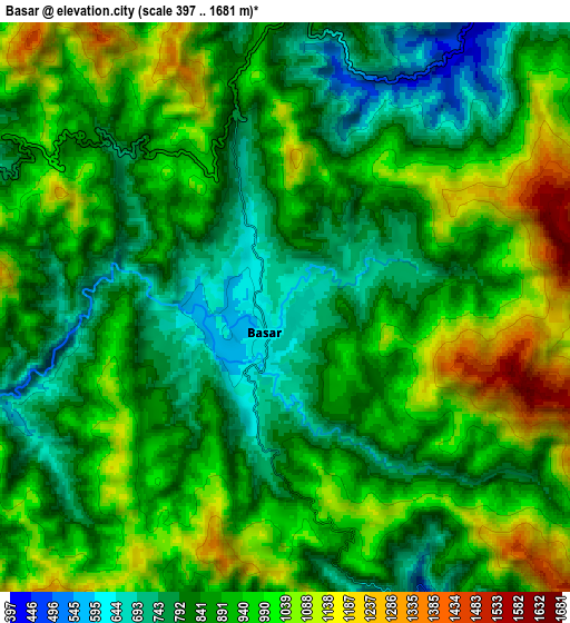
Below is the Elevation map of Bāsār, which displays elevation range with different colors. Scale of the first map is from 582 to 1234 m (1909 to 4049 ft) with average elevation of 776.3 meters (=2547 ft) [note 1]
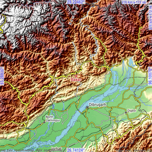
These maps also provides idea of topography and contour of this city, they are displayed at different zoom levels. More info about maps, scale and edge coordinates you can find below images.
| \ | Map #1 | Map #2 | Topo.Map |
| Scale [m] | 582..1234 m | 397..1681 m | × |
| Scale [ft] | 1909..4049 ft | 1302..5515 ft | × |
| Average | 776.3 m = 2547 ft | 909.5 m = 2984 ft | × |
| Width | 8.63 km = 5.4 mi | 17.26 km = 10.7 mi | 276.1 km = 171.6 mi |
| Height | 8.63 km = 5.4 mi | 17.26 km = 10.7 mi | 276.1 km = 171.6 mi |
| ↑Max Latitude | 28.028878° | 28.067662° | 29.22462° |
| Latitude at center | 27.99008° | 27.99008° | 27.99008° |
| ↓Min Latitude | 27.951268° | 27.912442° | 26.74124° |
| ← Min Longitude | 94.650565° | 94.606619° | 93.28826° |
| Longitude center | 94.69451° | 94.69451° | 94.69451° |
| →Max Longitude | 94.738455° | 94.782401° | 96.10076° |
Nearby cities:
Cities around Bāsār sort by population:
• Dibrugarh elevation 110 m
60.5 km,  159°
159°
• Tinsukia 128 m
86 km,  130°
130°
• Pāsighāt 179 m
62.6 km,  82°
82°
• Duliāgaon 120 m
91.4 km,  138°
138°
• Silapathar 119 m
44.1 km,  176°
176°
• Along 268 m
22.5 km,  27°
27°
• Mākum 130 m
92 km, 127°
• Ziro 1579 m
95 km,  242°
242°
• Dhemāji 110 m
57.4 km,  190°
190°
• Chābua 119 m
73.6 km, 140°
• Morānha 104 m
91.9 km,  166°
166°
• Pangin 509 m
37.8 km,  49°
49°
Multilingual:
 En español:
Bāsār elevación 620 m.
 En France:
Bāsār élévation 620 m.


Sources and notes:
- [note 1] Map square and city borders are not equal. Map elevation data is calculated only from area inside that square.
- [src 1] Elevation data from geonames database provided with same terms of usage.
- [src 2] The elevation map of Bāsār is generated using elevation data from NASA's 3 arcsec (90m) resolution SRTM data.
- [src 3] Base (background) map © OpenStreetMap contributors tiles are generated by Geofabrik and OpenTopoMap.
Copyright & License:
This Bāsār Elevation Map is licensed under CC BY-SA. You may reuse any part from this page, if you give a proper credit by linking to this URL:
 More info on terms of use page.