Ziro elevation
Ziro (Arunachal Pradesh, Lower Subansiri), India elevation is 1579 meters and Ziro elevation in feet is 5180 ft above sea level [src 1]. Ziro is a populated place (feature code) with elevation that is 1286 meters (4219 ft) bigger than average city elevation in India.
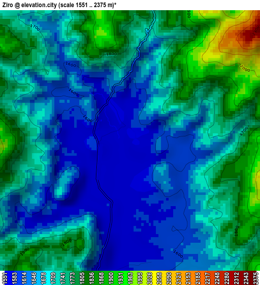
Below is the Elevation map of Ziro, which displays elevation range with different colors. Scale of the first map is from 1551 to 2375 m (5089 to 7792 ft) with average elevation of 1706.6 meters (=5599 ft) [note 1]
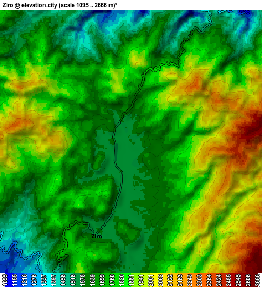
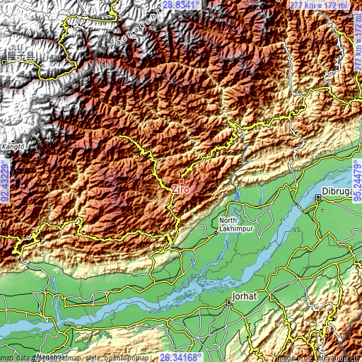
These maps also provides idea of topography and contour of this city, they are displayed at different zoom levels. More info about maps, scale and edge coordinates you can find below images.
| \ | Map #1 | Map #2 | Topo.Map |
| Scale [m] | 1551..2375 m | 1095..2666 m | × |
| Scale [ft] | 5089..7792 ft | 3593..8747 ft | × |
| Average | 1706.6 m = 5599 ft | 1773 m = 5817 ft | × |
| Width | 8.66 km = 5.4 mi | 17.32 km = 10.8 mi | 277.1 km = 172.2 mi |
| Height | 8.66 km = 5.4 mi | 17.32 km = 10.8 mi | 277.1 km = 172.2 mi |
| ↑Max Latitude | 27.633909° | 27.672835° | 28.8341° |
| Latitude at center | 27.59497° | 27.59497° | 27.59497° |
| ↓Min Latitude | 27.556017° | 27.51705° | 26.34168° |
| ← Min Longitude | 93.794595° | 93.750649° | 92.43229° |
| Longitude center | 93.83854° | 93.83854° | 93.83854° |
| →Max Longitude | 93.882485° | 93.926431° | 95.24479° |
Nearby cities:
Cities around Ziro sort by population:
• Jorhāt elevation 94 m
99.9 km,  158°
158°
• Sibsāgar 94 m
104.2 km,  130°
130°
• North Lakhimpur 96 m
47.8 km,  146°
146°
• Itānagar 326 m
60.8 km,  201°
201°
• Naharlagun 159 m
56.3 km,  194°
194°
• Silapathar 119 m
87.3 km,  90°
90°
• Dergaon 84 m
100.3 km,  172°
172°
• Dhemāji 110 m
74.5 km,  99°
99°
• Bihpuriāgaon 89 m
64.7 km, 173°
• Gohpur 84 m
82.3 km, 195°
• Bāsār 620 m
95 km,  62°
62°
• Garamur 77 m
79 km, 155°
Multilingual:
 En español:
Ziro elevación 1579 m.
 En France:
Ziro élévation 1579 m.


Sources and notes:
- [note 1] Map square and city borders are not equal. Map elevation data is calculated only from area inside that square.
- [src 1] Elevation data from geonames database provided with same terms of usage.
- [src 2] The elevation map of Ziro is generated using elevation data from NASA's 3 arcsec (90m) resolution SRTM data.
- [src 3] Base (background) map © OpenStreetMap contributors tiles are generated by Geofabrik and OpenTopoMap.
Copyright & License:
This Ziro Elevation Map is licensed under CC BY-SA. You may reuse any part from this page, if you give a proper credit by linking to this URL:
 More info on terms of use page.