Naharlagun elevation
Naharlagun (Arunachal Pradesh, Papum Pare), India elevation is 159 meters and Naharlagun elevation in feet is 522 ft above sea level [src 1]. Naharlagun is a populated place (feature code) with elevation that is 134 meters (440 ft) smaller than average city elevation in India.
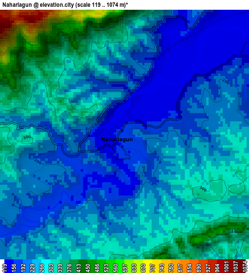
Below is the Elevation map of Naharlagun, which displays elevation range with different colors. Scale of the first map is from 119 to 1074 m (390 to 3524 ft) with average elevation of 257.5 meters (=845 ft) [note 1]
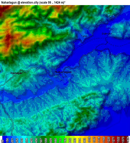
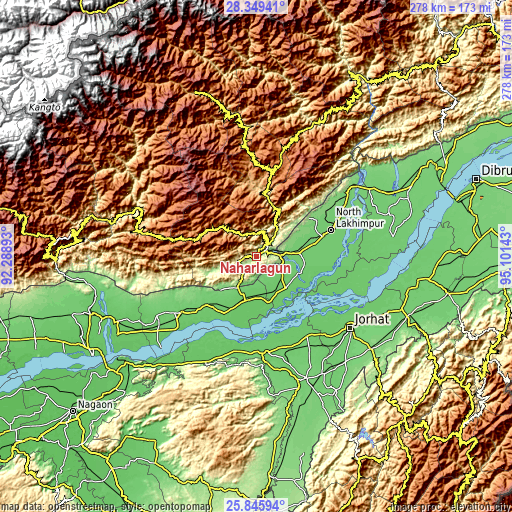
These maps also provides idea of topography and contour of this city, they are displayed at different zoom levels. More info about maps, scale and edge coordinates you can find below images.
| \ | Map #1 | Map #2 | Topo.Map |
| Scale [m] | 119..1074 m | 99..1424 m | × |
| Scale [ft] | 390..3524 ft | 325..4672 ft | × |
| Average | 257.5 m = 845 ft | 350.5 m = 1150 ft | × |
| Width | 8.7 km = 5.4 mi | 17.4 km = 10.8 mi | 278.4 km = 173 mi |
| Height | 8.7 km = 5.4 mi | 17.4 km = 10.8 mi | 278.4 km = 173 mi |
| ↑Max Latitude | 27.143782° | 27.182881° | 28.34941° |
| Latitude at center | 27.10467° | 27.10467° | 27.10467° |
| ↓Min Latitude | 27.065544° | 27.026405° | 25.84594° |
| ← Min Longitude | 93.651235° | 93.607289° | 92.28893° |
| Longitude center | 93.69518° | 93.69518° | 93.69518° |
| →Max Longitude | 93.739125° | 93.783071° | 95.10143° |
Nearby cities:
Cities around Naharlagun sort by population:
• Jorhāt elevation 94 m
63.4 km,  127°
127°
• North Lakhimpur 96 m
42.9 km,  70°
70°
• Itānagar 326 m
8.7 km,  256°
256°
• Golāghāt 101 m
71 km,  158°
158°
• Ziro 1579 m
56.3 km,  14°
14°
• Dergaon 84 m
52.4 km,  149°
149°
• Bihpuriāgaon 89 m
24 km,  113°
113°
• Gohpur 84 m
26 km,  197°
197°
• Bokākhāt 86 m
52.5 km,  190°
190°
• Numāligarh 99 m
53.7 km,  177°
177°
• Biswanath Chariali 86 m
68.8 km,  232°
232°
• Garamur 77 m
50.3 km, 110°
Multilingual:
 En español:
Naharlagun elevación 159 m.
 En France:
Naharlagun élévation 159 m.
 Auf Deutsch:
Naharlagun höhe über dem Meeresspiegel ist 159 m.

Sources and notes:
- [note 1] Map square and city borders are not equal. Map elevation data is calculated only from area inside that square.
- [src 1] Elevation data from geonames database provided with same terms of usage.
- [src 2] The elevation map of Naharlagun is generated using elevation data from NASA's 3 arcsec (90m) resolution SRTM data.
- [src 3] Base (background) map © OpenStreetMap contributors tiles are generated by Geofabrik and OpenTopoMap.
Copyright & License:
This Naharlagun Elevation Map is licensed under CC BY-SA. You may reuse any part from this page, if you give a proper credit by linking to this URL:
 More info on terms of use page.