Dergaon elevation
Dergaon (Assam, Golaghat), India elevation is 84 meters and Dergaon elevation in feet is 276 ft above sea level [src 1]. Dergaon is a populated place (feature code) with elevation that is 209 meters (686 ft) smaller than average city elevation in India.
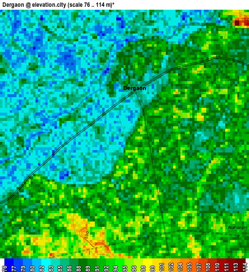
Below is the Elevation map of Dergaon, which displays elevation range with different colors. Scale of the first map is from 76 to 114 m (249 to 374 ft) with average elevation of 87.9 meters (=288 ft) [note 1]
These maps also provides idea of topography and contour of this city, they are displayed at different zoom levels. More info about maps, scale and edge coordinates you can find below images.
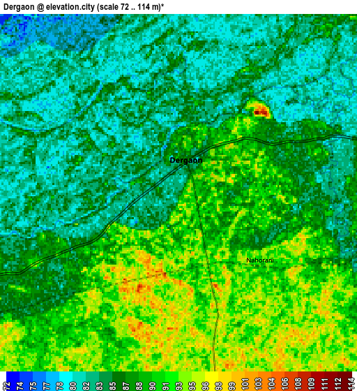
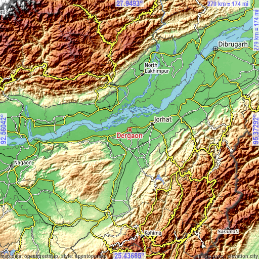
| \ | Map #1 | Map #2 | Topo.Map |
| Scale [m] | 76..114 m | 72..114 m | × |
| Scale [ft] | 249..374 ft | 236..374 ft | × |
| Average | 87.9 m = 288 ft | 87 m = 285 ft | × |
| Width | 8.73 km = 5.4 mi | 17.46 km = 10.8 mi | 279.4 km = 173.6 mi |
| Height | 8.73 km = 5.4 mi | 17.46 km = 10.8 mi | 279.4 km = 173.6 mi |
| ↑Max Latitude | 26.739253° | 26.778492° | 27.9493° |
| Latitude at center | 26.7° | 26.7° | 26.7° |
| ↓Min Latitude | 26.660734° | 26.621454° | 25.43685° |
| ← Min Longitude | 93.922725° | 93.878779° | 92.56042° |
| Longitude center | 93.96667° | 93.96667° | 93.96667° |
| →Max Longitude | 94.010615° | 94.054561° | 95.37292° |
Nearby cities:
Cities around Dergaon sort by population:
• Jorhāt elevation 94 m
24.3 km,  74°
74°
• Itānagar 326 m
55.7 km,  320°
320°
• Golāghāt 101 m
21 km,  181°
181°
• Naharlagun 159 m
52.4 km,  329°
329°
• Mariāni 118 m
35 km,  97°
97°
• Bihpuriāgaon 89 m
35.6 km,  352°
352°
• Gohpur 84 m
40.3 km,  300°
300°
• Bokākhāt 86 m
37 km,  259°
259°
• Titābar 102 m
26 km,  114°
114°
• Barpathār 123 m
46.6 km,  189°
189°
• Numāligarh 99 m
25.8 km,  250°
250°
• Garamur 77 m
34.4 km,  36°
36°
Multilingual:
 En español:
Dergaon elevación 84 m.
 En France:
Dergaon élévation 84 m.


Sources and notes:
- [note 1] Map square and city borders are not equal. Map elevation data is calculated only from area inside that square.
- [src 1] Elevation data from geonames database provided with same terms of usage.
- [src 2] The elevation map of Dergaon is generated using elevation data from NASA's 3 arcsec (90m) resolution SRTM data.
- [src 3] Base (background) map © OpenStreetMap contributors tiles are generated by Geofabrik and OpenTopoMap.
Copyright & License:
This Dergaon Elevation Map is licensed under CC BY-SA. You may reuse any part from this page, if you give a proper credit by linking to this URL:
 More info on terms of use page.