Morānha elevation
Morānha (Assam, Dibrugarh), India elevation is 104 meters and Morānha elevation in feet is 341 ft above sea level [src 1]. Morānha is a populated place (feature code) with elevation that is 189 meters (620 ft) smaller than average city elevation in India.
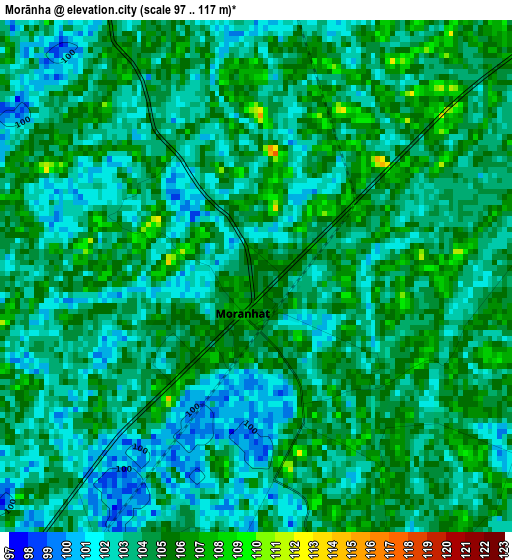
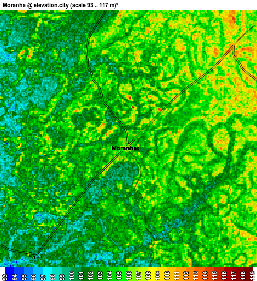
Below is the Elevation map of Morānha, which displays elevation range with different colors. Scale of the first map is from 97 to 117 m (318 to 384 ft) with average elevation of 103.5 meters (=340 ft) [note 1]
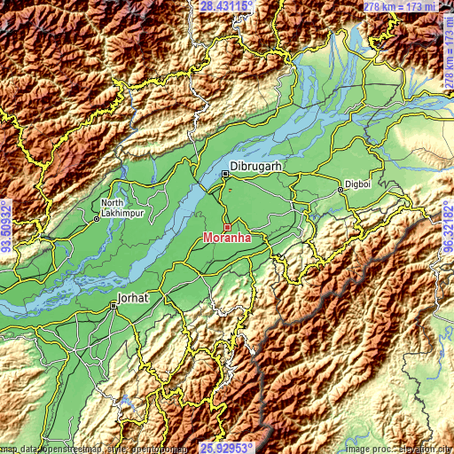
These maps also provides idea of topography and contour of this city, they are displayed at different zoom levels. More info about maps, scale and edge coordinates you can find below images.
| \ | Map #1 | Map #2 | Topo.Map |
| Scale [m] | 97..117 m | 93..117 m | × |
| Scale [ft] | 318..384 ft | 305..384 ft | × |
| Average | 103.5 m = 340 ft | 103.2 m = 339 ft | × |
| Width | 8.69 km = 5.4 mi | 17.39 km = 10.8 mi | 278.2 km = 172.9 mi |
| Height | 8.69 km = 5.4 mi | 17.39 km = 10.8 mi | 278.2 km = 172.9 mi |
| ↑Max Latitude | 27.226433° | 27.265503° | 28.43115° |
| Latitude at center | 27.18735° | 27.18735° | 27.18735° |
| ↓Min Latitude | 27.148253° | 27.109142° | 25.92953° |
| ← Min Longitude | 94.871625° | 94.827679° | 93.50932° |
| Longitude center | 94.91557° | 94.91557° | 94.91557° |
| →Max Longitude | 94.959515° | 95.003461° | 96.32182° |
Nearby cities:
Cities around Morānha sort by population:
• Dibrugarh elevation 110 m
32.5 km,  358°
358°
• Sibsāgar 94 m
35.6 km,  230°
230°
• Duliāgaon 120 m
43.9 km,  62°
62°
• Silapathar 119 m
49.1 km,  337°
337°
• Sonāri 106 m
20.7 km,  151°
151°
• Mon 1000 m
52.2 km,  164°
164°
• Nāmrup 123 m
39.9 km,  88°
88°
• Nahorkatiya 120 m
43.6 km,  74°
74°
• Nāzirā 101 m
35 km,  210°
210°
• Dhemāji 110 m
46.5 km,  315°
315°
• Chābua 119 m
41.6 km,  37°
37°
• Sonari 97 m
16.8 km,  138°
138°
Multilingual:
 En español:
Morānha elevación 104 m.
 En France:
Morānha élévation 104 m.


Sources and notes:
- [note 1] Map square and city borders are not equal. Map elevation data is calculated only from area inside that square.
- [src 1] Elevation data from geonames database provided with same terms of usage.
- [src 2] The elevation map of Morānha is generated using elevation data from NASA's 3 arcsec (90m) resolution SRTM data.
- [src 3] Base (background) map © OpenStreetMap contributors tiles are generated by Geofabrik and OpenTopoMap.
Copyright & License:
This Morānha Elevation Map is licensed under CC BY-SA. You may reuse any part from this page, if you give a proper credit by linking to this URL:
 More info on terms of use page.