Chābua elevation
Chābua (Assam, Dibrugarh), India elevation is 119 meters and Chābua elevation in feet is 390 ft above sea level [src 1]. Chābua is a populated place (feature code) with elevation that is 174 meters (571 ft) smaller than average city elevation in India.
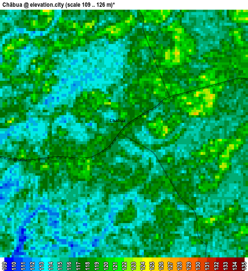
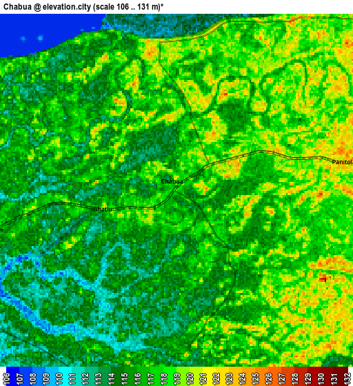
Below is the Elevation map of Chābua, which displays elevation range with different colors. Scale of the first map is from 109 to 126 m (358 to 413 ft) with average elevation of 116.1 meters (=381 ft) [note 1]
These maps also provides idea of topography and contour of this city, they are displayed at different zoom levels. More info about maps, scale and edge coordinates you can find below images.
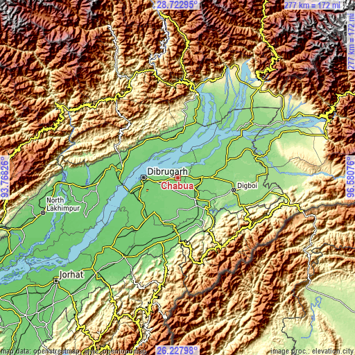
| \ | Map #1 | Map #2 | Topo.Map |
| Scale [m] | 109..126 m | 106..131 m | × |
| Scale [ft] | 358..413 ft | 348..430 ft | × |
| Average | 116.1 m = 381 ft | 116.1 m = 381 ft | × |
| Width | 8.67 km = 5.4 mi | 17.34 km = 10.8 mi | 277.4 km = 172.4 mi |
| Height | 8.67 km = 5.4 mi | 17.34 km = 10.8 mi | 277.4 km = 172.4 mi |
| ↑Max Latitude | 27.521509° | 27.560475° | 28.72295° |
| Latitude at center | 27.48253° | 27.48253° | 27.48253° |
| ↓Min Latitude | 27.443537° | 27.40453° | 26.22798° |
| ← Min Longitude | 95.130565° | 95.086619° | 93.76826° |
| Longitude center | 95.17451° | 95.17451° | 95.17451° |
| →Max Longitude | 95.218455° | 95.262401° | 96.58076° |
Nearby cities:
Cities around Chābua sort by population:
• Dibrugarh elevation 110 m
26.3 km,  269°
269°
• Tinsukia 128 m
18.3 km,  87°
87°
• Duliāgaon 120 m
18 km,  133°
133°
• Silapathar 119 m
46.1 km,  285°
285°
• Dum Duma 131 m
38.9 km,  75°
75°
• Digboi 153 m
44.9 km,  102°
102°
• Sonāri 106 m
53.3 km,  197°
197°
• Nāmrup 123 m
35.1 km,  155°
155°
• Mākum 130 m
25.8 km, 89°
• Nahorkatiya 120 m
27.1 km,  142°
142°
• Morānha 104 m
41.6 km,  217°
217°
• Sonari 97 m
47.7 km, 197°
Multilingual:
 En español:
Chābua elevación 119 m.
 En France:
Chābua élévation 119 m.


Sources and notes:
- [note 1] Map square and city borders are not equal. Map elevation data is calculated only from area inside that square.
- [src 1] Elevation data from geonames database provided with same terms of usage.
- [src 2] The elevation map of Chābua is generated using elevation data from NASA's 3 arcsec (90m) resolution SRTM data.
- [src 3] Base (background) map © OpenStreetMap contributors tiles are generated by Geofabrik and OpenTopoMap.
Copyright & License:
This Chābua Elevation Map is licensed under CC BY-SA. You may reuse any part from this page, if you give a proper credit by linking to this URL:
 More info on terms of use page.