Dibrugarh elevation
Dibrugarh (Assam), India elevation is 110 meters and Dibrugarh elevation in feet is 361 ft above sea level [src 1]. Dibrugarh is a seat of a second-order administrative division (feature code) with elevation that is 183 meters (600 ft) smaller than average city elevation in India.
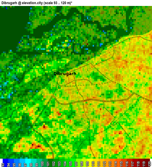
Below is the Elevation map of Dibrugarh, which displays elevation range with different colors. Scale of the first map is from 93 to 120 m (305 to 394 ft) with average elevation of 106.5 meters (=349 ft) [note 1]
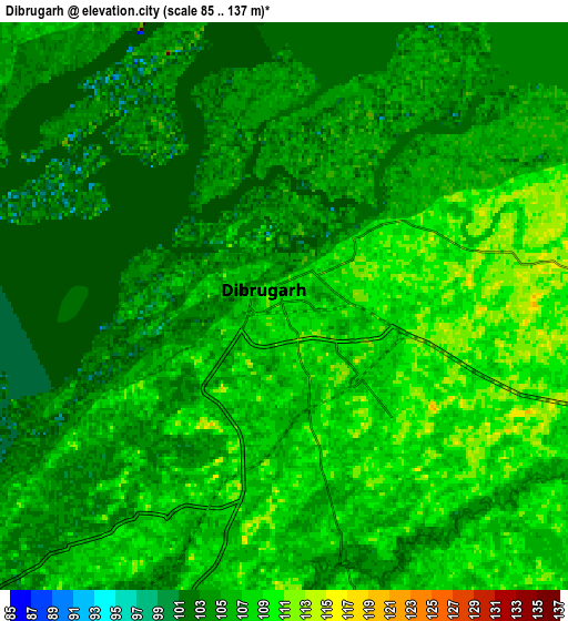
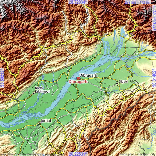
These maps also provides idea of topography and contour of this city, they are displayed at different zoom levels. More info about maps, scale and edge coordinates you can find below images.
| \ | Map #1 | Map #2 | Topo.Map |
| Scale [m] | 93..120 m | 85..137 m | × |
| Scale [ft] | 305..394 ft | 279..449 ft | × |
| Average | 106.5 m = 349 ft | 106.1 m = 348 ft | × |
| Width | 8.67 km = 5.4 mi | 17.34 km = 10.8 mi | 277.4 km = 172.4 mi |
| Height | 8.67 km = 5.4 mi | 17.34 km = 10.8 mi | 277.4 km = 172.4 mi |
| ↑Max Latitude | 27.51887° | 27.557837° | 28.72034° |
| Latitude at center | 27.47989° | 27.47989° | 27.47989° |
| ↓Min Latitude | 27.440896° | 27.401888° | 26.22531° |
| ← Min Longitude | 94.864425° | 94.820479° | 93.50212° |
| Longitude center | 94.90837° | 94.90837° | 94.90837° |
| →Max Longitude | 94.952315° | 94.996261° | 96.31462° |
Nearby cities:
Cities around Dibrugarh sort by population:
• Tinsukia elevation 128 m
44.6 km,  88°
88°
• Duliāgaon 120 m
41.2 km,  106°
106°
• Silapathar 119 m
22.2 km,  305°
305°
• Sonāri 106 m
51.7 km,  168°
168°
• Nāmrup 123 m
51.6 km,  128°
128°
• Mākum 130 m
52.1 km, 89°
• Nahorkatiya 120 m
47.8 km,  116°
116°
• Dhemāji 110 m
32.1 km,  270°
270°
• Chābua 119 m
26.3 km, 89°
• Morānha 104 m
32.5 km,  178°
178°
• Bāsār 620 m
60.5 km,  339°
339°
• Sonari 97 m
46.7 km, 165°
Multilingual:
 En español:
Dibrugarh elevación 110 m.
 En France:
Dibrugarh élévation 110 m.
 Auf Deutsch:
Dibrugarh höhe über dem Meeresspiegel ist 110 m.

Sources and notes:
- [note 1] Map square and city borders are not equal. Map elevation data is calculated only from area inside that square.
- [src 1] Elevation data from geonames database provided with same terms of usage.
- [src 2] The elevation map of Dibrugarh is generated using elevation data from NASA's 3 arcsec (90m) resolution SRTM data.
- [src 3] Base (background) map © OpenStreetMap contributors tiles are generated by Geofabrik and OpenTopoMap.
Copyright & License:
This Dibrugarh Elevation Map is licensed under CC BY-SA. You may reuse any part from this page, if you give a proper credit by linking to this URL:
 More info on terms of use page.