Udaipur elevation
Udaipur (Rajasthan), India elevation is 565 meters and Udaipur elevation in feet is 1854 ft above sea level [src 1]. Udaipur is a populated place (feature code) with elevation that is 272 meters (892 ft) bigger than average city elevation in India.
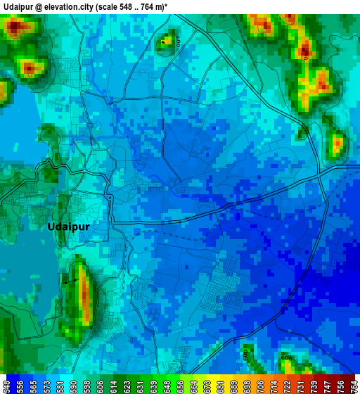
Below is the Elevation map of Udaipur, which displays elevation range with different colors. Scale of the first map is from 548 to 764 m (1798 to 2507 ft) with average elevation of 586.1 meters (=1923 ft) [note 1]
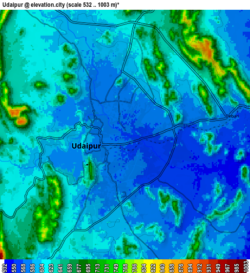
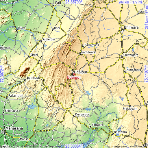
These maps also provides idea of topography and contour of this city, they are displayed at different zoom levels. More info about maps, scale and edge coordinates you can find below images.
| \ | Map #1 | Map #2 | Topo.Map |
| Scale [m] | 548..764 m | 532..1003 m | × |
| Scale [ft] | 1798..2507 ft | 1745..3291 ft | × |
| Average | 586.1 m = 1923 ft | 611.9 m = 2008 ft | × |
| Width | 8.89 km = 5.5 mi | 17.77 km = 11 mi | 284.4 km = 176.7 mi |
| Height | 8.89 km = 5.5 mi | 17.77 km = 11 mi | 284.4 km = 176.7 mi |
| ↑Max Latitude | 24.625795° | 24.665737° | 25.85799° |
| Latitude at center | 24.58584° | 24.58584° | 24.58584° |
| ↓Min Latitude | 24.545872° | 24.505892° | 23.30064° |
| ← Min Longitude | 73.669515° | 73.625569° | 72.30721° |
| Longitude center | 73.71346° | 73.71346° | 73.71346° |
| →Max Longitude | 73.757405° | 73.801351° | 75.11971° |
Nearby cities:
Cities around Udaipur sort by population:
• Rājsamand elevation 548 m
56.5 km,  17°
17°
• Dūngarpur 292 m
82.6 km,  179°
179°
• Nāthdwāra 585 m
40.7 km, 15°
• Sādri 360 m
71.7 km,  338°
338°
• Pindwāra 375 m
70.6 km,  289°
289°
• Bāli 299 m
80.2 km,  327°
327°
• Amet 584 m
82.9 km,  14°
14°
• Bhindār 496 m
48.6 km,  101°
101°
• Sālūmbar 242 m
60.3 km,  146°
146°
• Bari Sādri 500 m
79.2 km, 104°
• Kānor 479 m
58.3 km,  106°
106°
• Dariba 494 m
58.6 km,  46°
46°
Multilingual:
 En español:
Udaipur elevación 565 m.
 En France:
Udaipur élévation 565 m.


Sources and notes:
- [note 1] Map square and city borders are not equal. Map elevation data is calculated only from area inside that square.
- [src 1] Elevation data from geonames database provided with same terms of usage.
- [src 2] The elevation map of Udaipur is generated using elevation data from NASA's 3 arcsec (90m) resolution SRTM data.
- [src 3] Base (background) map © OpenStreetMap contributors tiles are generated by Geofabrik and OpenTopoMap.
Copyright & License:
This Udaipur Elevation Map is licensed under CC BY-SA. You may reuse any part from this page, if you give a proper credit by linking to this URL:
 More info on terms of use page.