Rājsamand elevation
Rājsamand (Rajasthan, Rajsamand), India elevation is 548 meters and Rājsamand elevation in feet is 1798 ft above sea level [src 1]. Rājsamand is a populated place (feature code) with elevation that is 255 meters (837 ft) bigger than average city elevation in India.
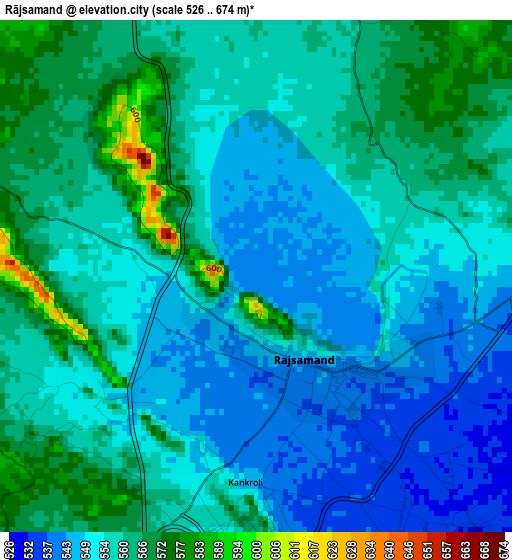
Below is the Elevation map of Rājsamand, which displays elevation range with different colors. Scale of the first map is from 526 to 674 m (1726 to 2211 ft) with average elevation of 556.9 meters (=1827 ft) [note 1]
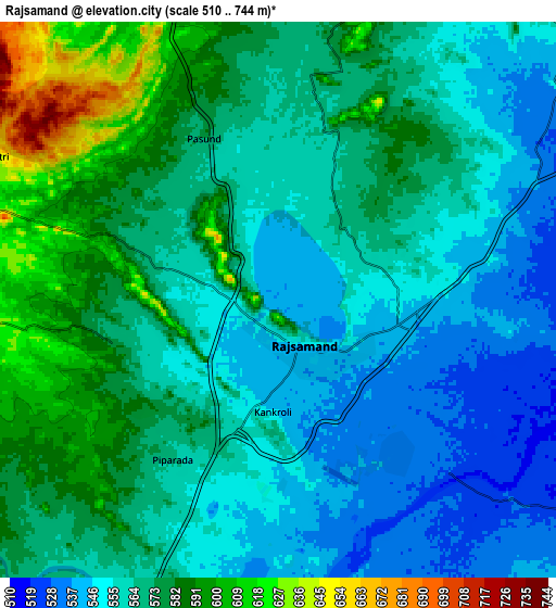
These maps also provides idea of topography and contour of this city, they are displayed at different zoom levels. More info about maps, scale and edge coordinates you can find below images.
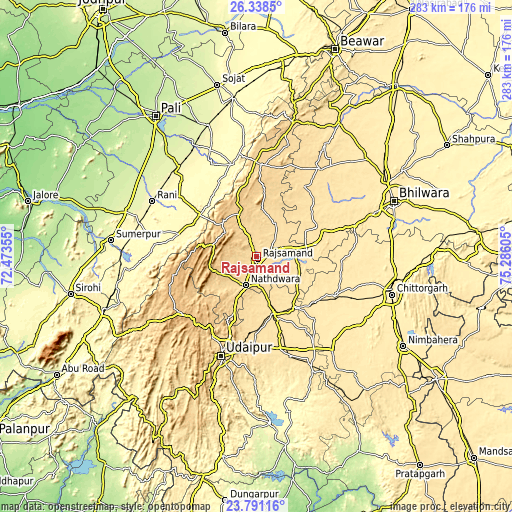
| \ | Map #1 | Map #2 | Topo.Map |
| Scale [m] | 526..674 m | 510..744 m | × |
| Scale [ft] | 1726..2211 ft | 1673..2441 ft | × |
| Average | 556.9 m = 1827 ft | 566.6 m = 1859 ft | × |
| Width | 8.85 km = 5.5 mi | 17.7 km = 11 mi | 283.2 km = 176 mi |
| Height | 8.85 km = 5.5 mi | 17.7 km = 11 mi | 283.3 km = 176 mi |
| ↑Max Latitude | 25.111248° | 25.151034° | 26.3385° |
| Latitude at center | 25.07145° | 25.07145° | 25.07145° |
| ↓Min Latitude | 25.031639° | 24.991815° | 23.79116° |
| ← Min Longitude | 73.835855° | 73.791909° | 72.47355° |
| Longitude center | 73.8798° | 73.8798° | 73.8798° |
| →Max Longitude | 73.923745° | 73.967691° | 75.28605° |
Nearby cities:
Cities around Rājsamand sort by population:
• Udaipur elevation 565 m
56.5 km,  197°
197°
• Chittaurgarh 405 m
77.7 km,  105°
105°
• Nāthdwāra 585 m
15.9 km, 200°
• Sādri 360 m
44.8 km,  286°
286°
• Māndal 437 m
80.7 km,  59°
59°
• Bāli 299 m
60.9 km,  283°
283°
• Gangāpur 508 m
41.7 km,  66°
66°
• Devgarh 638 m
50.5 km,  3°
3°
• Amet 584 m
26.5 km,  10°
10°
• Bhindār 496 m
70.4 km,  154°
154°
• Rāni 281 m
65.3 km,  298°
298°
• Dariba 494 m
29 km,  118°
118°
Multilingual:
 En español:
Rājsamand elevación 548 m.
 En France:
Rājsamand élévation 548 m.
 Auf Deutsch:
Rājsamand höhe über dem Meeresspiegel ist 548 m.

Sources and notes:
- [note 1] Map square and city borders are not equal. Map elevation data is calculated only from area inside that square.
- [src 1] Elevation data from geonames database provided with same terms of usage.
- [src 2] The elevation map of Rājsamand is generated using elevation data from NASA's 3 arcsec (90m) resolution SRTM data.
- [src 3] Base (background) map © OpenStreetMap contributors tiles are generated by Geofabrik and OpenTopoMap.
Copyright & License:
This Rājsamand Elevation Map is licensed under CC BY-SA. You may reuse any part from this page, if you give a proper credit by linking to this URL:
 More info on terms of use page.