Amet elevation
Amet (Rajasthan, Rajsamand), India elevation is 584 meters and Amet elevation in feet is 1916 ft above sea level [src 1]. Amet is a populated place (feature code) with elevation that is 291 meters (955 ft) bigger than average city elevation in India.
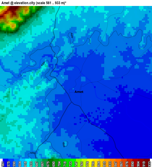
Below is the Elevation map of Amet, which displays elevation range with different colors. Scale of the first map is from 561 to 933 m (1841 to 3061 ft) with average elevation of 603.7 meters (=1981 ft) [note 1]
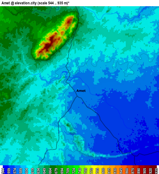
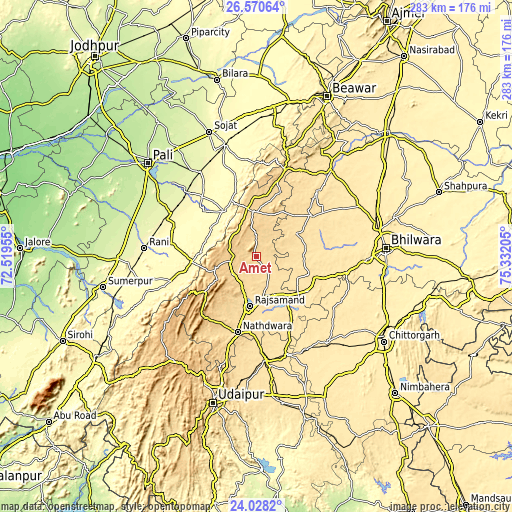
These maps also provides idea of topography and contour of this city, they are displayed at different zoom levels. More info about maps, scale and edge coordinates you can find below images.
| \ | Map #1 | Map #2 | Topo.Map |
| Scale [m] | 561..933 m | 544..935 m | × |
| Scale [ft] | 1841..3061 ft | 1785..3068 ft | × |
| Average | 603.7 m = 1981 ft | 616.4 m = 2022 ft | × |
| Width | 8.83 km = 5.5 mi | 17.67 km = 11 mi | 282.7 km = 175.7 mi |
| Height | 8.83 km = 5.5 mi | 17.67 km = 11 mi | 282.7 km = 175.7 mi |
| ↑Max Latitude | 25.345812° | 25.38552° | 26.57064° |
| Latitude at center | 25.30609° | 25.30609° | 25.30609° |
| ↓Min Latitude | 25.266355° | 25.226608° | 24.0282° |
| ← Min Longitude | 73.881855° | 73.837909° | 72.51955° |
| Longitude center | 73.9258° | 73.9258° | 73.9258° |
| →Max Longitude | 73.969745° | 74.013691° | 75.33205° |
Nearby cities:
Cities around Amet sort by population:
• Bhīlwāra elevation 419 m
72 km,  86°
86°
• Rājsamand 548 m
26.5 km,  190°
190°
• Sojat 280 m
73.6 km,  339°
339°
• Nāthdwāra 585 m
42.2 km, 194°
• Sādri 360 m
49.4 km,  254°
254°
• Māndal 437 m
66.4 km,  76°
76°
• Bāli 299 m
65 km,  259°
259°
• Gangāpur 508 m
35 km,  105°
105°
• Devgarh 638 m
24.4 km,  355°
355°
• Āsind 478 m
62.7 km,  40°
40°
• Rāni 281 m
62.2 km,  274°
274°
• Dariba 494 m
44.9 km,  152°
152°
Multilingual:
 En español:
Amet elevación 584 m.
 En France:
Amet élévation 584 m.


Sources and notes:
- [note 1] Map square and city borders are not equal. Map elevation data is calculated only from area inside that square.
- [src 1] Elevation data from geonames database provided with same terms of usage.
- [src 2] The elevation map of Amet is generated using elevation data from NASA's 3 arcsec (90m) resolution SRTM data.
- [src 3] Base (background) map © OpenStreetMap contributors tiles are generated by Geofabrik and OpenTopoMap.
Copyright & License:
This Amet Elevation Map is licensed under CC BY-SA. You may reuse any part from this page, if you give a proper credit by linking to this URL:
 More info on terms of use page.