Bhīlwāra elevation
Bhīlwāra (Rajasthan), India elevation is 419 meters and Bhīlwāra elevation in feet is 1375 ft above sea level [src 1]. Bhīlwāra is a populated place (feature code) with elevation that is 126 meters (413 ft) bigger than average city elevation in India.
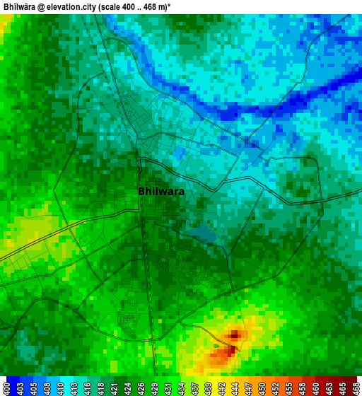
Below is the Elevation map of Bhīlwāra, which displays elevation range with different colors. Scale of the first map is from 400 to 468 m (1312 to 1535 ft) with average elevation of 421.3 meters (=1382 ft) [note 1]
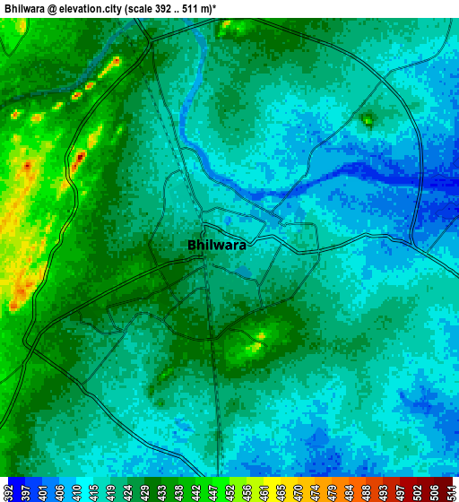
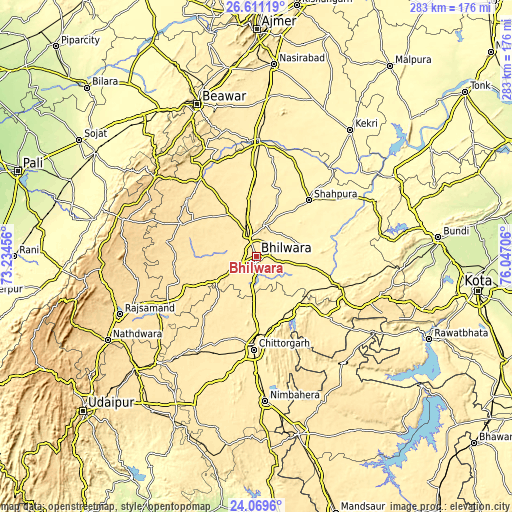
These maps also provides idea of topography and contour of this city, they are displayed at different zoom levels. More info about maps, scale and edge coordinates you can find below images.
| \ | Map #1 | Map #2 | Topo.Map |
| Scale [m] | 400..468 m | 392..511 m | × |
| Scale [ft] | 1312..1535 ft | 1286..1677 ft | × |
| Average | 421.3 m = 1382 ft | 422.6 m = 1386 ft | × |
| Width | 8.83 km = 5.5 mi | 17.66 km = 11 mi | 282.6 km = 175.6 mi |
| Height | 8.83 km = 5.5 mi | 17.66 km = 11 mi | 282.6 km = 175.6 mi |
| ↑Max Latitude | 25.386778° | 25.426473° | 26.61119° |
| Latitude at center | 25.34707° | 25.34707° | 25.34707° |
| ↓Min Latitude | 25.307349° | 25.267614° | 24.0696° |
| ← Min Longitude | 74.596865° | 74.552919° | 73.23456° |
| Longitude center | 74.64081° | 74.64081° | 74.64081° |
| →Max Longitude | 74.684755° | 74.728701° | 76.04706° |
Nearby cities:
Cities around Bhīlwāra sort by population:
• Chittaurgarh elevation 405 m
50.9 km,  181°
181°
• Shāhpura 371 m
41.7 km,  43°
43°
• Gulābpura 400 m
62 km,  1°
1°
• Māndal 437 m
12.7 km,  325°
325°
• Māndalgarh 380 m
46.6 km,  111°
111°
• Begūn 420 m
54.2 km,  138°
138°
• Jahāzpur 343 m
70.6 km,  64°
64°
• Gangāpur 508 m
40.8 km,  249°
249°
• Amet 584 m
72 km,  266°
266°
• Āsind 478 m
53 km,  324°
324°
• Ratangarh 441 m
76 km, 140°
• Dariba 494 m
67.5 km,  229°
229°
Multilingual:
 En español:
Bhīlwāra elevación 419 m.
 En France:
Bhīlwāra élévation 419 m.
 Auf Deutsch:
Bhīlwāra höhe über dem Meeresspiegel ist 419 m.

Sources and notes:
- [note 1] Map square and city borders are not equal. Map elevation data is calculated only from area inside that square.
- [src 1] Elevation data from geonames database provided with same terms of usage.
- [src 2] The elevation map of Bhīlwāra is generated using elevation data from NASA's 3 arcsec (90m) resolution SRTM data.
- [src 3] Base (background) map © OpenStreetMap contributors tiles are generated by Geofabrik and OpenTopoMap.
Copyright & License:
This Bhīlwāra Elevation Map is licensed under CC BY-SA. You may reuse any part from this page, if you give a proper credit by linking to this URL:
 More info on terms of use page.