Kānor elevation
Kānor (Rajasthan, Udaipur), India elevation is 479 meters and Kānor elevation in feet is 1572 ft above sea level [src 1]. Kānor is a populated place (feature code) with elevation that is 186 meters (610 ft) bigger than average city elevation in India.
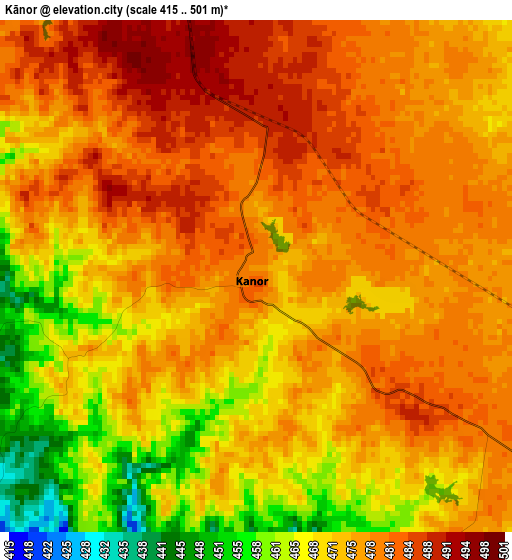
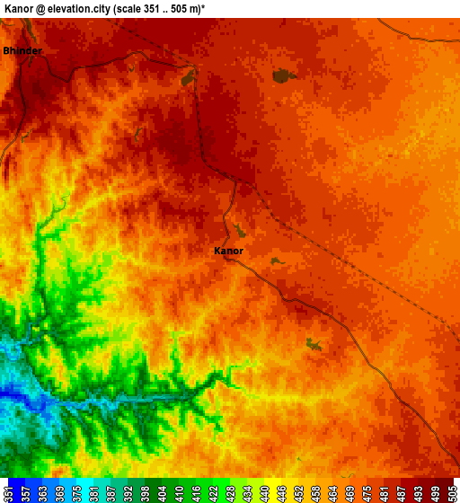
Below is the Elevation map of Kānor, which displays elevation range with different colors. Scale of the first map is from 415 to 501 m (1362 to 1644 ft) with average elevation of 474.4 meters (=1556 ft) [note 1]
These maps also provides idea of topography and contour of this city, they are displayed at different zoom levels. More info about maps, scale and edge coordinates you can find below images.
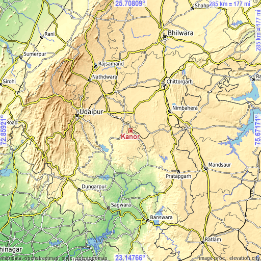
| \ | Map #1 | Map #2 | Topo.Map |
| Scale [m] | 415..501 m | 351..505 m | × |
| Scale [ft] | 1362..1644 ft | 1152..1657 ft | × |
| Average | 474.4 m = 1556 ft | 463.9 m = 1522 ft | × |
| Width | 8.9 km = 5.5 mi | 17.79 km = 11.1 mi | 284.7 km = 176.9 mi |
| Height | 8.9 km = 5.5 mi | 17.79 km = 11.1 mi | 284.7 km = 176.9 mi |
| ↑Max Latitude | 24.474373° | 24.514363° | 25.70809° |
| Latitude at center | 24.43437° | 24.43437° | 24.43437° |
| ↓Min Latitude | 24.394354° | 24.354326° | 23.14766° |
| ← Min Longitude | 74.221515° | 74.177569° | 72.85921° |
| Longitude center | 74.26546° | 74.26546° | 74.26546° |
| →Max Longitude | 74.309405° | 74.353351° | 75.67171° |
Nearby cities:
Cities around Kānor sort by population:
• Udaipur elevation 565 m
58.3 km,  286°
286°
• Chittaurgarh 405 m
62.3 km,  35°
35°
• Nīmbāhera 447 m
46.8 km,  63°
63°
• Pratāpgarh 498 m
68.8 km,  130°
130°
• Chhoti Sādri 498 m
44.5 km,  97°
97°
• Bhindār 496 m
11.1 km,  313°
313°
• Jāwad 467 m
63.1 km,  73°
73°
• Sālūmbar 242 m
40.1 km,  213°
213°
• Bari Sādri 500 m
21.2 km, 96°
• Jīran 485 m
64.9 km, 102°
• Dariba 494 m
58.7 km,  346°
346°
• Neemuch 488 m
60.6 km,  85°
85°
Multilingual:
 En español:
Kānor elevación 479 m.
 En France:
Kānor élévation 479 m.


Sources and notes:
- [note 1] Map square and city borders are not equal. Map elevation data is calculated only from area inside that square.
- [src 1] Elevation data from geonames database provided with same terms of usage.
- [src 2] The elevation map of Kānor is generated using elevation data from NASA's 3 arcsec (90m) resolution SRTM data.
- [src 3] Base (background) map © OpenStreetMap contributors tiles are generated by Geofabrik and OpenTopoMap.
Copyright & License:
This Kānor Elevation Map is licensed under CC BY-SA. You may reuse any part from this page, if you give a proper credit by linking to this URL:
 More info on terms of use page.