Umarkot elevation
Umarkot (Chhattisgarh), India elevation is 615 meters and Umarkot elevation in feet is 2018 ft above sea level [src 1]. Umarkot is a populated place (feature code) with elevation that is 322 meters (1056 ft) bigger than average city elevation in India.
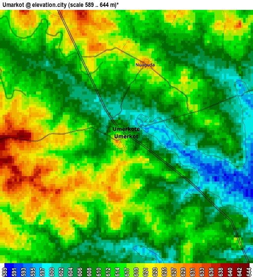
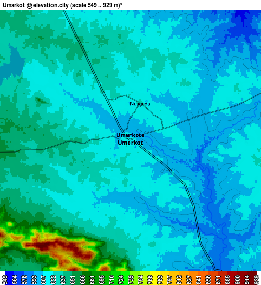
Below is the Elevation map of Umarkot, which displays elevation range with different colors. Scale of the first map is from 589 to 644 m (1932 to 2113 ft) with average elevation of 612.8 meters (=2010 ft) [note 1]
These maps also provides idea of topography and contour of this city, they are displayed at different zoom levels. More info about maps, scale and edge coordinates you can find below images.
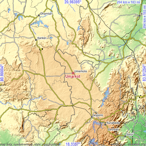
| \ | Map #1 | Map #2 | Topo.Map |
| Scale [m] | 589..644 m | 549..929 m | × |
| Scale [ft] | 1932..2113 ft | 1801..3048 ft | × |
| Average | 612.8 m = 2010 ft | 624.4 m = 2049 ft | × |
| Width | 9.2 km = 5.7 mi | 18.41 km = 11.4 mi | 294.5 km = 183 mi |
| Height | 9.2 km = 5.7 mi | 18.41 km = 11.4 mi | 294.5 km = 183 mi |
| ↑Max Latitude | 19.706667° | 19.748033° | 20.98395° |
| Latitude at center | 19.66529° | 19.66529° | 19.66529° |
| ↓Min Latitude | 19.623902° | 19.582504° | 18.3357° |
| ← Min Longitude | 82.162345° | 82.118399° | 80.80004° |
| Longitude center | 82.20629° | 82.20629° | 82.20629° |
| →Max Longitude | 82.250235° | 82.294181° | 83.61254° |
Nearby cities:
Cities around Umarkot sort by population:
• Nowrangapur elevation 578 m
60.1 km,  143°
143°
• Jeypore 592 m
97.8 km,  156°
156°
• Jagdalpur 562 m
67.8 km,  196°
196°
• Bhawānipatna 259 m
104 km,  75°
75°
• Korāput 883 m
108.6 km,  150°
150°
• Kondagaon 597 m
57.4 km,  261°
261°
• Kānker 401 m
100.6 km,  312°
312°
• Jūnāgarh 226 m
79.1 km,  74°
74°
• Kotapārh 561 m
59.4 km,  167°
167°
• Kharhiāl 244 m
90.3 km,  39°
39°
• Gariāband 348 m
108.7 km,  352°
352°
• Narharpur 402 m
106.5 km,  324°
324°
Multilingual:
 En español:
Umarkot elevación 615 m.
 En France:
Umarkot élévation 615 m.


Sources and notes:
- [note 1] Map square and city borders are not equal. Map elevation data is calculated only from area inside that square.
- [src 1] Elevation data from geonames database provided with same terms of usage.
- [src 2] The elevation map of Umarkot is generated using elevation data from NASA's 3 arcsec (90m) resolution SRTM data.
- [src 3] Base (background) map © OpenStreetMap contributors tiles are generated by Geofabrik and OpenTopoMap.
Copyright & License:
This Umarkot Elevation Map is licensed under CC BY-SA. You may reuse any part from this page, if you give a proper credit by linking to this URL:
 More info on terms of use page.