Korāput elevation
Korāput (Odisha, Koraput), India elevation is 883 meters and Korāput elevation in feet is 2897 ft above sea level [src 1]. Korāput is a populated place (feature code) with elevation that is 590 meters (1936 ft) bigger than average city elevation in India.
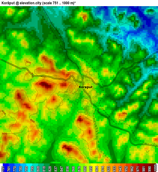
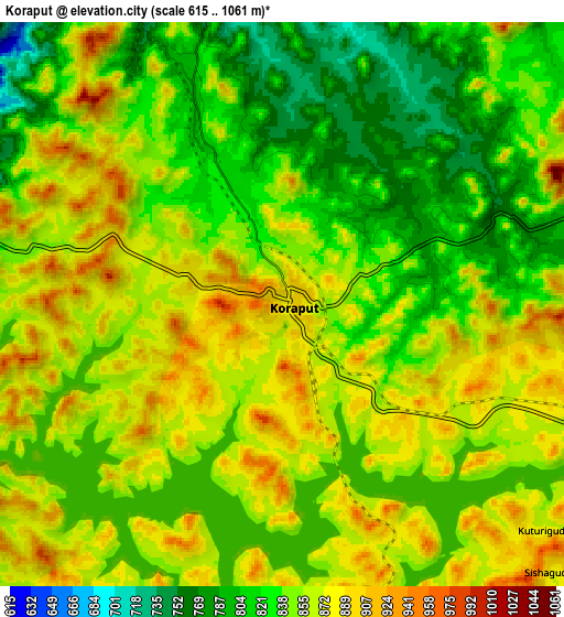
Below is the Elevation map of Korāput, which displays elevation range with different colors. Scale of the first map is from 751 to 1000 m (2464 to 3281 ft) with average elevation of 862.1 meters (=2828 ft) [note 1]
These maps also provides idea of topography and contour of this city, they are displayed at different zoom levels. More info about maps, scale and edge coordinates you can find below images.
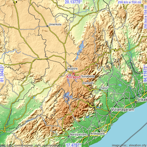
| \ | Map #1 | Map #2 | Topo.Map |
| Scale [m] | 751..1000 m | 615..1061 m | × |
| Scale [ft] | 2464..3281 ft | 2018..3481 ft | × |
| Average | 862.1 m = 2828 ft | 850.7 m = 2791 ft | × |
| Width | 9.25 km = 5.7 mi | 18.5 km = 11.5 mi | 296 km = 183.9 mi |
| Height | 9.25 km = 5.7 mi | 18.5 km = 11.5 mi | 296 km = 183.9 mi |
| ↑Max Latitude | 18.853583° | 18.895165° | 20.13775° |
| Latitude at center | 18.81199° | 18.81199° | 18.81199° |
| ↓Min Latitude | 18.770387° | 18.728774° | 17.4757° |
| ← Min Longitude | 82.666535° | 82.622589° | 81.30423° |
| Longitude center | 82.71048° | 82.71048° | 82.71048° |
| →Max Longitude | 82.754425° | 82.798371° | 84.11673° |
Nearby cities:
Cities around Korāput sort by population:
• Nowrangapur elevation 578 m
49.6 km,  339°
339°
• Jeypore 592 m
15.4 km,  288°
288°
• Jagdalpur 562 m
78.4 km, 292°
• Bobbili 135 m
73.3 km,  111°
111°
• Pārvatipuram 128 m
75.3 km,  92°
92°
• Sālūr 160 m
61.6 km,  122°
122°
• Chīpurupalle 106 m
106.2 km, 121°
• Malakanagiri 189 m
100 km,  240°
240°
• Kotapārh 561 m
54.7 km,  312°
312°
• Mādugula 97 m
100.3 km,  173°
173°
• Balimila 210 m
89.1 km,  225°
225°
• Chittarkonda 414 m
99.3 km,  219°
219°
Multilingual:
 En español:
Korāput elevación 883 m.
 En France:
Korāput élévation 883 m.


Sources and notes:
- [note 1] Map square and city borders are not equal. Map elevation data is calculated only from area inside that square.
- [src 1] Elevation data from geonames database provided with same terms of usage.
- [src 2] The elevation map of Korāput is generated using elevation data from NASA's 3 arcsec (90m) resolution SRTM data.
- [src 3] Base (background) map © OpenStreetMap contributors tiles are generated by Geofabrik and OpenTopoMap.
Copyright & License:
This Korāput Elevation Map is licensed under CC BY-SA. You may reuse any part from this page, if you give a proper credit by linking to this URL:
 More info on terms of use page.