Chittarkonda elevation
Chittarkonda (Odisha, Malkangiri), India elevation is 414 meters and Chittarkonda elevation in feet is 1358 ft above sea level [src 1]. Chittarkonda is a populated place (feature code) with elevation that is 121 meters (397 ft) bigger than average city elevation in India.
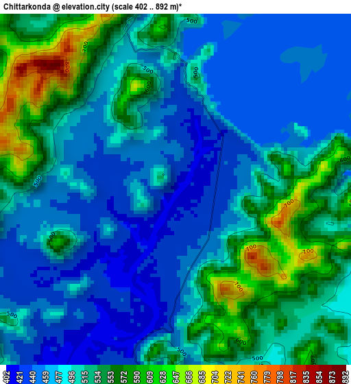
Below is the Elevation map of Chittarkonda, which displays elevation range with different colors. Scale of the first map is from 402 to 892 m (1319 to 2927 ft) with average elevation of 502.4 meters (=1648 ft) [note 1]
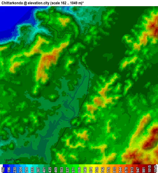
These maps also provides idea of topography and contour of this city, they are displayed at different zoom levels. More info about maps, scale and edge coordinates you can find below images.
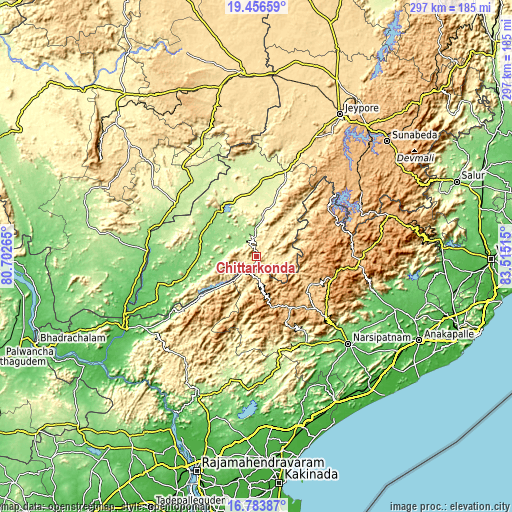
| \ | Map #1 | Map #2 | Topo.Map |
| Scale [m] | 402..892 m | 162..1049 m | × |
| Scale [ft] | 1319..2927 ft | 531..3442 ft | × |
| Average | 502.4 m = 1648 ft | 498.4 m = 1635 ft | × |
| Width | 9.29 km = 5.8 mi | 18.58 km = 11.5 mi | 297.2 km = 184.7 mi |
| Height | 9.29 km = 5.8 mi | 18.58 km = 11.5 mi | 297.2 km = 184.7 mi |
| ↑Max Latitude | 18.16709° | 18.208839° | 19.45659° |
| Latitude at center | 18.12533° | 18.12533° | 18.12533° |
| ↓Min Latitude | 18.08356° | 18.041781° | 16.78387° |
| ← Min Longitude | 82.064955° | 82.021009° | 80.70265° |
| Longitude center | 82.1089° | 82.1089° | 82.1089° |
| →Max Longitude | 82.152845° | 82.196791° | 83.51515° |
Nearby cities:
Cities around Chittarkonda sort by population:
• Jeypore elevation 592 m
94.8 km,  30°
30°
• Tuni 24 m
97 km,  151°
151°
• Korāput 883 m
99.3 km,  39°
39°
• Narsīpatnam 85 m
73.7 km,  133°
133°
• Chodavaram 48 m
93.4 km,  110°
110°
• Rampachodavaram 182 m
83.9 km,  204°
204°
• Malakanagiri 189 m
35.4 km,  318°
318°
• Mādugula 97 m
78.3 km, 107°
• Balimila 210 m
14 km,  359°
359°
• Etikoppāka 229 m
95.9 km,  136°
136°
• Akasahebpet 71 m
84.3 km, 144°
• Sukma 208 m
55.9 km,  301°
301°
Multilingual:
 En español:
Chittarkonda elevación 414 m.
 En France:
Chittarkonda élévation 414 m.
 Auf Deutsch:
Chittarkonda höhe über dem Meeresspiegel ist 414 m.

Sources and notes:
- [note 1] Map square and city borders are not equal. Map elevation data is calculated only from area inside that square.
- [src 1] Elevation data from geonames database provided with same terms of usage.
- [src 2] The elevation map of Chittarkonda is generated using elevation data from NASA's 3 arcsec (90m) resolution SRTM data.
- [src 3] Base (background) map © OpenStreetMap contributors tiles are generated by Geofabrik and OpenTopoMap.
Copyright & License:
This Chittarkonda Elevation Map is licensed under CC BY-SA. You may reuse any part from this page, if you give a proper credit by linking to this URL:
 More info on terms of use page.