Chodavaram elevation
Chodavaram (Andhra Pradesh, Vishākhapatnam), India elevation is 48 meters and Chodavaram elevation in feet is 157 ft above sea level [src 1]. Chodavaram is a populated place (feature code) with elevation that is 245 meters (804 ft) smaller than average city elevation in India.
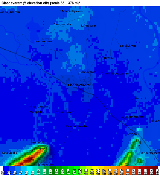
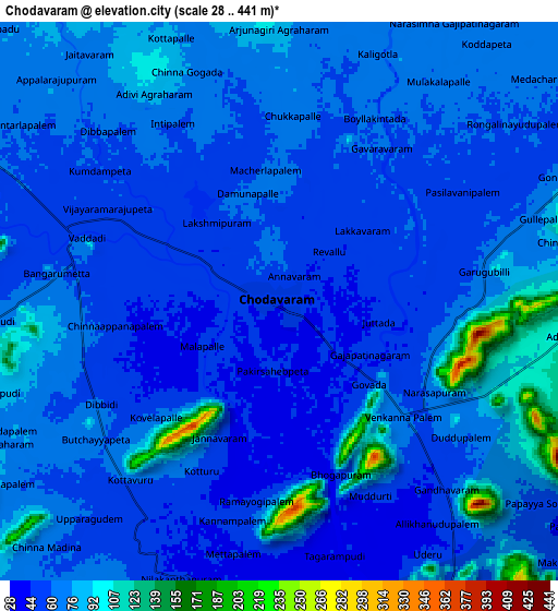
Below is the Elevation map of Chodavaram, which displays elevation range with different colors. Scale of the first map is from 33 to 376 m (108 to 1234 ft) with average elevation of 53.7 meters (=176 ft) [note 1]
These maps also provides idea of topography and contour of this city, they are displayed at different zoom levels. More info about maps, scale and edge coordinates you can find below images.
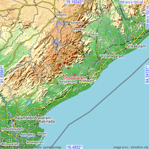
| \ | Map #1 | Map #2 | Topo.Map |
| Scale [m] | 33..376 m | 28..441 m | × |
| Scale [ft] | 108..1234 ft | 92..1447 ft | × |
| Average | 53.7 m = 176 ft | 66.2 m = 217 ft | × |
| Width | 9.3 km = 5.8 mi | 18.61 km = 11.6 mi | 297.7 km = 185 mi |
| Height | 9.3 km = 5.8 mi | 18.61 km = 11.6 mi | 297.7 km = 185 mi |
| ↑Max Latitude | 17.87067° | 17.91249° | 19.16242° |
| Latitude at center | 17.82884° | 17.82884° | 17.82884° |
| ↓Min Latitude | 17.787° | 17.745151° | 16.4852° |
| ← Min Longitude | 82.891315° | 82.847369° | 81.52901° |
| Longitude center | 82.93526° | 82.93526° | 82.93526° |
| →Max Longitude | 82.979205° | 83.023151° | 84.34151° |
Nearby cities:
Cities around Chodavaram sort by population:
• Visakhapatnam elevation 24 m
32.7 km,  120°
120°
• Gajuwaka 17 m
33.1 km, 115°
• Vizianagaram 66 m
59.7 km,  57°
57°
• Anakāpalle 34 m
16.9 km,  154°
154°
• Bhīmunipatnam 21 m
55.1 km,  82°
82°
• Narsīpatnam 85 m
38.6 km,  242°
242°
• Vepagunta 54 m
30.2 km,  100°
100°
• Elamanchili 18 m
32.2 km,  194°
194°
• Mādugula 97 m
15.9 km,  307°
307°
• Etikoppāka 229 m
42.4 km,  210°
210°
• Yārāda 10 m
40.6 km, 117°
• Akasahebpet 71 m
53.2 km,  227°
227°
Multilingual:
 En español:
Chodavaram elevación 48 m.
 En France:
Chodavaram élévation 48 m.
 Auf Deutsch:
Chodavaram höhe über dem Meeresspiegel ist 48 m.

Sources and notes:
- [note 1] Map square and city borders are not equal. Map elevation data is calculated only from area inside that square.
- [src 1] Elevation data from geonames database provided with same terms of usage.
- [src 2] The elevation map of Chodavaram is generated using elevation data from NASA's 3 arcsec (90m) resolution SRTM data.
- [src 3] Base (background) map © OpenStreetMap contributors tiles are generated by Geofabrik and OpenTopoMap.
Copyright & License:
This Chodavaram Elevation Map is licensed under CC BY-SA. You may reuse any part from this page, if you give a proper credit by linking to this URL:
 More info on terms of use page.